Le Burgaud
Le Burgaud | |
|---|---|
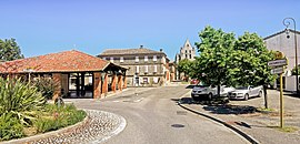 The center of the village. | |
 Coat of arms | |
show Location of Le Burgaud | |
 Le Burgaud | |
| Coordinates: 43°47′44″N 1°09′47″E / 43.7956°N 1.1631°ECoordinates: 43°47′44″N 1°09′47″E / 43.7956°N 1.1631°E | |
| Country | France |
| Region | Occitanie |
| Department | Haute-Garonne |
| Arrondissement | Toulouse |
| Canton | Léguevin |
| Government | |
| • Mayor (2008–2014) | Didier Roujean |
| Area 1 | 24.18 km2 (9.34 sq mi) |
| Population (Jan. 2018)[1] | 972 |
| • Density | 40/km2 (100/sq mi) |
| Time zone | UTC+01:00 (CET) |
| • Summer (DST) | UTC+02:00 (CEST) |
| INSEE/Postal code | 31093 /31330 |
| Elevation | 143–253 m (469–830 ft) (avg. 158 m or 518 ft) |
| 1 French Land Register data, which excludes lakes, ponds, glaciers > 1 km2 (0.386 sq mi or 247 acres) and river estuaries. | |


Le Burgaud is a commune of the Haute-Garonne department in southwestern France.
Population[]
| Year | Pop. | ±% |
|---|---|---|
| 1962 | 329 | — |
| 1968 | 419 | +27.4% |
| 1975 | 397 | −5.3% |
| 1982 | 419 | +5.5% |
| 1990 | 429 | +2.4% |
| 1999 | 484 | +12.8% |
| 2008 | 617 | +27.5% |

The town hall

The church Saint-Jean-Baptiste

The covered market


See also[]
References[]
- ^ "Populations légales 2018". INSEE. 28 December 2020.
| Wikimedia Commons has media related to Le Burgaud. |
This Haute-Garonne geographical article is a stub. You can help Wikipedia by . |
Categories:
- Communes of Haute-Garonne
- Haute-Garonne geography stubs