Puydaniel
show This article may be expanded with text translated from the corresponding article in French. (February 2017) Click [show] for important translation instructions. |
Puydaniel | |
|---|---|
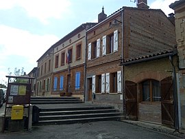 The town hall in Puydaniel | |
 Coat of arms | |
show Location of Puydaniel | |
 Puydaniel | |
| Coordinates: 43°20′13″N 1°26′00″E / 43.3369°N 1.4333°ECoordinates: 43°20′13″N 1°26′00″E / 43.3369°N 1.4333°E | |
| Country | France |
| Region | Occitanie |
| Department | Haute-Garonne |
| Arrondissement | Muret |
| Canton | Auterive |
| Government | |
| • Mayor (2020–2026) | Jean-Claude Blanc[1] |
| Area 1 | 7.38 km2 (2.85 sq mi) |
| Population (Jan. 2018)[2] | 535 |
| • Density | 72/km2 (190/sq mi) |
| Time zone | UTC+01:00 (CET) |
| • Summer (DST) | UTC+02:00 (CEST) |
| INSEE/Postal code | 31442 /31190 |
| Elevation | 187–322 m (614–1,056 ft) (avg. 205 m or 673 ft) |
| 1 French Land Register data, which excludes lakes, ponds, glaciers > 1 km2 (0.386 sq mi or 247 acres) and river estuaries. | |


Puydaniel is a commune in the Haute-Garonne department in southwestern France.
Population[]
| Year | Pop. | ±% |
|---|---|---|
| 1962 | 180 | — |
| 1968 | 192 | +6.7% |
| 1975 | 231 | +20.3% |
| 1982 | 273 | +18.2% |
| 1990 | 294 | +7.7% |
| 1999 | 318 | +8.2% |
| 2008 | 393 | +23.6% |
| 2018 | 535 | +36.1% |
See also[]
References[]
- ^ "Répertoire national des élus: les maires". data.gouv.fr, Plateforme ouverte des données publiques françaises (in French). 2 December 2020.
- ^ "Populations légales 2018". INSEE. 28 December 2020.
| Wikimedia Commons has media related to Puydaniel. |
This Haute-Garonne geographical article is a stub. You can help Wikipedia by . |
Categories:
- Communes of Haute-Garonne
- Haute-Garonne geography stubs