Rambluzin-et-Benoite-Vaux
Rambluzin-et-Benoite-Vaux | |
|---|---|
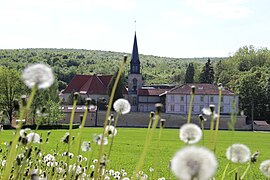 A general view of Benoite-Vaux | |
 Coat of arms | |
show Location of Rambluzin-et-Benoite-Vaux | |
 Rambluzin-et-Benoite-Vaux | |
| Coordinates: 48°59′54″N 5°20′09″E / 48.9983°N 5.3358°ECoordinates: 48°59′54″N 5°20′09″E / 48.9983°N 5.3358°E | |
| Country | France |
| Region | Grand Est |
| Department | Meuse |
| Arrondissement | Verdun |
| Canton | Dieue-sur-Meuse |
| Intercommunality | Val de Meuse - Voie Sacrée |
| Government | |
| • Mayor (2020–2026) | Thiphanie Banel |
| Area 1 | 18.42 km2 (7.11 sq mi) |
| Population (Jan. 2018)[1] | 104 |
| • Density | 5.6/km2 (15/sq mi) |
| Time zone | UTC+01:00 (CET) |
| • Summer (DST) | UTC+02:00 (CEST) |
| INSEE/Postal code | 55411 /55220 |
| Elevation | 227–337 m (745–1,106 ft) (avg. 300 m or 980 ft) |
| 1 French Land Register data, which excludes lakes, ponds, glaciers > 1 km2 (0.386 sq mi or 247 acres) and river estuaries. | |


Rambluzin-et-Benoite-Vaux (French pronunciation: [ʁɑ̃blyzɛ̃ e bənwat vo]) is a commune in the Meuse department in Grand Est in north-eastern France.
See also[]
References[]
- ^ "Populations légales 2018". INSEE. 28 December 2020.
| Wikimedia Commons has media related to Rambluzin-et-Benoite-Vaux. |
| show Authority control |
|---|
This Meuse geographical article is a stub. You can help Wikipedia by . |
Categories:
- Communes of Meuse (department)
- Meuse (department) geography stubs