Villematier
Villematier | |
|---|---|
 The church in Villematier | |
show Location of Villematier | |
 Villematier | |
| Coordinates: 43°49′48″N 1°30′33″E / 43.83°N 1.5092°ECoordinates: 43°49′48″N 1°30′33″E / 43.83°N 1.5092°E | |
| Country | France |
| Region | Occitanie |
| Department | Haute-Garonne |
| Arrondissement | Toulouse |
| Canton | Villemur-sur-Tarn |
| Intercommunality | Val'Aïgo |
| Government | |
| • Mayor (2020–2026) | Jean-Michel Jilibert[1] |
| Area 1 | 14.96 km2 (5.78 sq mi) |
| Population (Jan. 2018)[2] | 1,068 |
| • Density | 71/km2 (180/sq mi) |
| Time zone | UTC+01:00 (CET) |
| • Summer (DST) | UTC+02:00 (CEST) |
| INSEE/Postal code | 31583 /31340 |
| Elevation | 85–156 m (279–512 ft) (avg. 103 m or 338 ft) |
| 1 French Land Register data, which excludes lakes, ponds, glaciers > 1 km2 (0.386 sq mi or 247 acres) and river estuaries. | |


Villematier (French pronunciation: [vilmatje]; Occitan: Vilamatièr) is a commune in the Haute-Garonne department in southwestern France.
Population[]
| Year | Pop. | ±% |
|---|---|---|
| 1962 | 557 | — |
| 1968 | 652 | +17.1% |
| 1975 | 714 | +9.5% |
| 1982 | 827 | +15.8% |
| 1990 | 828 | +0.1% |
| 1999 | 861 | +4.0% |
| 2008 | 971 | +12.8% |
Sights[]
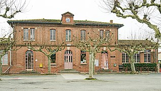
Town hall

See also[]
References[]
- ^ "Répertoire national des élus: les maires". data.gouv.fr, Plateforme ouverte des données publiques françaises (in French). 2 December 2020.
- ^ "Populations légales 2018". INSEE. 28 December 2020.
| Wikimedia Commons has media related to Villematier. |
This Haute-Garonne geographical article is a stub. You can help Wikipedia by . |
Categories:
- Communes of Haute-Garonne
- Haute-Garonne geography stubs