Amayé-sur-Orne
Amayé-sur-Orne | |
|---|---|
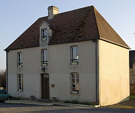 The Town Hall | |
 Coat of arms | |
show Location of Amayé-sur-Orne | |
 Amayé-sur-Orne | |
| Coordinates: 49°05′09″N 0°26′16″W / 49.0858°N 0.4378°WCoordinates: 49°05′09″N 0°26′16″W / 49.0858°N 0.4378°W | |
| Country | France |
| Region | Normandy |
| Department | Calvados |
| Arrondissement | Caen |
| Canton | Évrecy |
| Intercommunality | |
| Government | |
| • Mayor (2020–2026) | Sylvain Colino[1] |
| Area 1 | 5.29 km2 (2.04 sq mi) |
| Population (Jan. 2018)[2] | 1,009 |
| • Density | 190/km2 (490/sq mi) |
| Time zone | UTC+01:00 (CET) |
| • Summer (DST) | UTC+02:00 (CEST) |
| INSEE/Postal code | 14006 /14210 |
| Elevation | 7–109 m (23–358 ft) (avg. 50 m or 160 ft) |
| 1 French Land Register data, which excludes lakes, ponds, glaciers > 1 km2 (0.386 sq mi or 247 acres) and river estuaries. | |


Amayé-sur-Orne (French pronunciation: [amaje syʁ ɔʁn] (![]() listen), literally Amayé on Orne) is a commune in the Calvados department in the Normandy region of northwestern France. Its inhabitants are known as Amayéens or Amayéennes[3]
listen), literally Amayé on Orne) is a commune in the Calvados department in the Normandy region of northwestern France. Its inhabitants are known as Amayéens or Amayéennes[3]
Geography[]
Amayé-sur-Orne is located approximately 10 km south-west of Caen and 5 km east of Évrecy. It can be accessed by road D212 from Vieux in the north which continues south to Thury-Harcourt and by road D41 from Evrecy in the west which continues to Clinchamps-sur-Orne in the east. Closely located to the town are a number of hamlets including: Saint-Lambert, La Butte, Le Pont du Coudray, and Les Godets. These villages form a single conurbation with the village. The rest of the commune is entirely farmland.[4]
The eastern border of the commune is formed by the Orne river. A stream, flows through the village and down to the Orne and another stream flowing to the Orne forms the southern boundary of the commune. The Guigne stream forms the northern border of the commune and also flows to the Orne.[4]
Heraldry[]
 |
Blazon: Party per fesse, the first gules a Danish cross of Or voided, to dexter chief two lions passant gardant the same; the second Vert, fess in chief argent, a chevron inverted of Or and chief of Or, a castel azure of two towers domed argent with walls sloped.
|
Administration[]

This list is incomplete; you can help by . (April 2021) |
List of Successive Mayors of Amayé-sur-Orne[5]
| From | To | Name | Party | Position |
|---|---|---|---|---|
| 1987 | 1994 | Jacques Dolley | ind. | Professor |
| 1994 | 2001 | André Porcher | ind. | CEO |
| 2001 | 2008 | Nicole Perly | ind. | |
| 2008 | 2026 | Sylvain Colino | ind. | Fire-fighter |
Twinning[]
Amayé-sur-Orne has twinning associations with:[6]
 Johannesberg (Germany) since 1991.
Population[]
| Year | Pop. | ±% |
|---|---|---|
| 2006 | 945 | — |
| 2007 | 982 | +3.9% |
| 2008 | 1,019 | +3.8% |
| 2009 | 1,024 | +0.5% |
| 2010 | 1,026 | +0.2% |
| 2011 | 1,015 | −1.1% |
| 2012 | 1,004 | −1.1% |
| 2013 | 993 | −1.1% |
| 2014 | 988 | −0.5% |
| 2015 | 985 | −0.3% |
| 2016 | 993 | +0.8% |
Sites and Monuments[]

- The Ifs Cemetery is a listed site (SC 9 January 1933)[7]
- The 'Butte de l'Orne is another World Heritage Site (SC 9 January 1933)
- A Lavoir (Public laundry)
- The Chateau de la Butte (19th century)
- The Chateau de Vaux (18th century)
The Bell Tower Attic of the Church of Notre Dame hosts breeding colonies of large bats and is a registered Site of Community Importance (SIC)[8]
Gallery[]

A yew tree in the cemetery
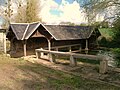
The Lavoir
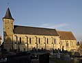
The Church of Notre-Dame

Church of Notre Dame bell tower
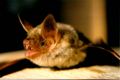
Greater mouse-eared bat


See also[]
- Communes of the Calvados department
References[]
- ^ "Répertoire national des élus: les maires". data.gouv.fr, Plateforme ouverte des données publiques françaises (in French). 2 December 2020.
- ^ "Populations légales 2018". INSEE. 28 December 2020.
- ^ Inhabitants of Calvados (in French)
- ^ Jump up to: a b c Google Maps
- ^ List of Mayors of France (in French)
- ^ National Commission for Decentralised cooperation (in French)
- ^ DREAL Basse-Normandie (in French)
- ^ Site of Community Importance (SIC) - Attic of the church of Amayé-sur-Orne[permanent dead link], Ministry of Ecology and sustainable development (in French)
External links[]
- Amayé-sur-Orne on Lion1906
- Amayé-sur-Orne on Géoportail, National Geographic Institute (IGN) website (in French)
- Amayé-sur-Orne on the 1750 Cassini Map
| Wikimedia Commons has media related to Amayé-sur-Orne. |
| show Communes of the Calvados department |
|---|
| show Authority control |
|---|
- Communes of Calvados (department)