Blangy-le-Château
show This article may be expanded with text translated from the corresponding article in French. (December 2008) Click [show] for important translation instructions. |
Blangy-le-Château | |
|---|---|
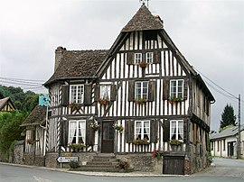 A timber-framed house in Blangy-le-Château | |
 Coat of arms | |
show Location of Blangy-le-Château | |
 Blangy-le-Château | |
| Coordinates: 49°14′42″N 0°16′28″E / 49.245°N 0.2744°ECoordinates: 49°14′42″N 0°16′28″E / 49.245°N 0.2744°E | |
| Country | France |
| Region | Normandy |
| Department | Calvados |
| Arrondissement | Lisieux |
| Canton | Pont-l'Évêque |
| Government | |
| • Mayor (2020–2026) | Dorian Coge |
| Area 1 | 10.62 km2 (4.10 sq mi) |
| Population (Jan. 2018)[1] | 699 |
| • Density | 66/km2 (170/sq mi) |
| Time zone | UTC+01:00 (CET) |
| • Summer (DST) | UTC+02:00 (CEST) |
| INSEE/Postal code | 14077 /14130 |
| Elevation | 38–162 m (125–531 ft) (avg. 78 m or 256 ft) |
| 1 French Land Register data, which excludes lakes, ponds, glaciers > 1 km2 (0.386 sq mi or 247 acres) and river estuaries. | |


Blangy-le-Château (French pronunciation: [blɑ̃ʒi lə ʃato] (![]() listen)) is a commune in the Calvados department in the Normandy region in northwestern France.
listen)) is a commune in the Calvados department in the Normandy region in northwestern France.
Population[]
| Year | Pop. | ±% |
|---|---|---|
| 1962 | 524 | — |
| 1968 | 532 | +1.5% |
| 1975 | 585 | +10.0% |
| 1982 | 612 | +4.6% |
| 1990 | 618 | +1.0% |
| 1999 | 627 | +1.5% |
| 2008 | 672 | +7.2% |
See also[]
- Communes of the Calvados department
References[]
- ^ "Populations légales 2018". INSEE. 28 December 2020.
| Wikimedia Commons has media related to Blangy-le-Château. |
| show Communes of the Calvados department |
|---|
| show Authority control |
|---|
This Calvados geographical article is a stub. You can help Wikipedia by . |
Categories:
- Communes of Calvados (department)
- Calvados (department) geography stubs