Périgny, Calvados
show This article may be expanded with text translated from the corresponding article in French. (December 2008) Click [show] for important translation instructions. |
Périgny | |
|---|---|
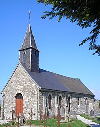 The church in Périgny | |
show Location of Périgny | |
 Périgny | |
| Coordinates: 48°55′22″N 0°36′14″W / 48.9227°N 0.6038°WCoordinates: 48°55′22″N 0°36′14″W / 48.9227°N 0.6038°W | |
| Country | France |
| Region | Normandy |
| Department | Calvados |
| Arrondissement | Vire |
| Canton | Condé-sur-Noireau |
| Government | |
| • Mayor (2008–2014) | Dominique Mullois |
| Area 1 | 2.66 km2 (1.03 sq mi) |
| Population (Jan. 2018)[1] | 58 |
| • Density | 22/km2 (56/sq mi) |
| Time zone | UTC+01:00 (CET) |
| • Summer (DST) | UTC+02:00 (CEST) |
| INSEE/Postal code | 14496 /14770 |
| Elevation | 120–232 m (394–761 ft) (avg. 214 m or 702 ft) |
| 1 French Land Register data, which excludes lakes, ponds, glaciers > 1 km2 (0.386 sq mi or 247 acres) and river estuaries. | |


Périgny is a commune in the Calvados department in the Normandy region in northwestern France.
Population[]
| Year | Pop. | ±% |
|---|---|---|
| 1962 | 80 | — |
| 1968 | 77 | −3.7% |
| 1975 | 60 | −22.1% |
| 1982 | 47 | −21.7% |
| 1990 | 53 | +12.8% |
| 1999 | 62 | +17.0% |
| 2008 | 53 | −14.5% |
See also[]
- Communes of the Calvados department
References[]
- ^ "Populations légales 2018". INSEE. 28 December 2020.
External links[]
| Wikimedia Commons has media related to Périgny (Calvados). |
- History and stories from Périgny (in French)
| show Communes of the Calvados department |
|---|
| show Authority control |
|---|
This Calvados geographical article is a stub. You can help Wikipedia by . |
Categories:
- Communes of Calvados (department)
- Calvados (department) geography stubs