Mutrécy
Mutrécy | |
|---|---|
 Town hall | |
show Location of Mutrécy | |
 Mutrécy | |
| Coordinates: 49°03′51″N 0°25′15″W / 49.0642°N 0.4208°WCoordinates: 49°03′51″N 0°25′15″W / 49.0642°N 0.4208°W | |
| Country | France |
| Region | Normandy |
| Department | Calvados |
| Arrondissement | Caen |
| Canton | Thury-Harcourt |
| Intercommunality | Cingal-Suisse Normande |
| Government | |
| • Mayor (2020–2026) | Gérard Valentin[1] |
| Area 1 | 6.71 km2 (2.59 sq mi) |
| Population (Jan. 2018)[2] | 429 |
| • Density | 64/km2 (170/sq mi) |
| Time zone | UTC+01:00 (CET) |
| • Summer (DST) | UTC+02:00 (CEST) |
| INSEE/Postal code | 14461 /14220 |
| Elevation | 7–104 m (23–341 ft) (avg. 85 m or 279 ft) |
| 1 French Land Register data, which excludes lakes, ponds, glaciers > 1 km2 (0.386 sq mi or 247 acres) and river estuaries. | |


Mutrécy is a commune in the Calvados department in the Normandy region in northwestern France.
Population[]
| Year | Pop. | ±% |
|---|---|---|
| 1962 | 203 | — |
| 1968 | 189 | −6.9% |
| 1975 | 207 | +9.5% |
| 1982 | 216 | +4.3% |
| 1990 | 219 | +1.4% |
| 1999 | 266 | +21.5% |
| 2008 | 329 | +23.7% |
See also[]
- Communes of the Calvados department
References[]
- ^ "Répertoire national des élus: les maires". data.gouv.fr, Plateforme ouverte des données publiques françaises (in French). 2 December 2020.
- ^ "Populations légales 2018". INSEE. 28 December 2020.
Gallery[]
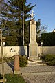
War memorial
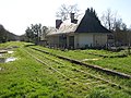
Station platforms
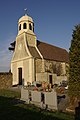
11th century church of Saint-Clair
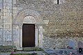
Side door of church


| Wikimedia Commons has media related to Mutrécy. |
| show Communes of the Calvados department |
|---|
This Calvados geographical article is a stub. You can help Wikipedia by . |
Categories:
- Communes of Calvados (department)
- Calvados (department) geography stubs