Clarbec
show This article may be expanded with text translated from the corresponding article in French. (December 2008) Click [show] for important translation instructions. |
Clarbec | |
|---|---|
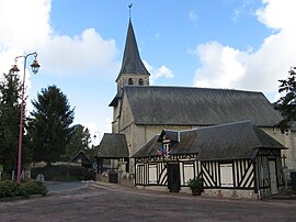 The church in Clarbec | |
 Coat of arms | |
show Location of Clarbec | |
 Clarbec | |
| Coordinates: 49°15′02″N 0°08′04″E / 49.2506°N 0.1344°ECoordinates: 49°15′02″N 0°08′04″E / 49.2506°N 0.1344°E | |
| Country | France |
| Region | Normandy |
| Department | Calvados |
| Arrondissement | Lisieux |
| Canton | Pont-l'Évêque |
| Government | |
| • Mayor (2008–2014) | Jean-Louis Marie |
| Area 1 | 9.7 km2 (3.7 sq mi) |
| Population (Jan. 2018)[1] | 352 |
| • Density | 36/km2 (94/sq mi) |
| Time zone | UTC+01:00 (CET) |
| • Summer (DST) | UTC+02:00 (CEST) |
| INSEE/Postal code | 14161 /14130 |
| Elevation | 47–140 m (154–459 ft) (avg. 90 m or 300 ft) |
| 1 French Land Register data, which excludes lakes, ponds, glaciers > 1 km2 (0.386 sq mi or 247 acres) and river estuaries. | |


Clarbec is a commune in the Calvados department in the Normandy region in northwestern France.
Population[]
| Year | Pop. | ±% |
|---|---|---|
| 1962 | 274 | — |
| 1968 | 309 | +12.8% |
| 1975 | 265 | −14.2% |
| 1982 | 251 | −5.3% |
| 1990 | 264 | +5.2% |
| 1999 | 275 | +4.2% |
| 2008 | 361 | +31.3% |
International relations[]
Clarbec is twinned with Veitshöchheim, Germany since 1995.
See also[]
- Communes of the Calvados department
References[]
- ^ "Populations légales 2018". INSEE. 28 December 2020.
| Wikimedia Commons has media related to Clarbec. |
| show Communes of the Calvados department |
|---|
This Calvados geographical article is a stub. You can help Wikipedia by . |
Categories:
- Communes of Calvados (department)
- Calvados (department) geography stubs