Rubercy
show This article may be expanded with text translated from the corresponding article in French. (December 2008) Click [show] for important translation instructions. |
Rubercy | |
|---|---|
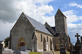 The church in Rubercy | |
show Location of Rubercy | |
 Rubercy | |
| Coordinates: 49°17′03″N 0°52′41″W / 49.2842°N 0.8781°WCoordinates: 49°17′03″N 0°52′41″W / 49.2842°N 0.8781°W | |
| Country | France |
| Region | Normandy |
| Department | Calvados |
| Arrondissement | Bayeux |
| Canton | Trévières |
| Intercommunality | CC Isigny-Omaha Intercom |
| Government | |
| • Mayor (2020–2026) | Michel Mariette[1] |
| Area 1 | 5.54 km2 (2.14 sq mi) |
| Population (Jan. 2018)[2] | 164 |
| • Density | 30/km2 (77/sq mi) |
| Time zone | UTC+01:00 (CET) |
| • Summer (DST) | UTC+02:00 (CEST) |
| INSEE/Postal code | 14547 /14710 |
| Elevation | 5–74 m (16–243 ft) (avg. 9 m or 30 ft) |
| 1 French Land Register data, which excludes lakes, ponds, glaciers > 1 km2 (0.386 sq mi or 247 acres) and river estuaries. | |


Rubercy is a commune in the Calvados department in the Normandy region in northwestern France.
Population[]
| Year | Pop. | ±% |
|---|---|---|
| 123 | 1,968 | — |
| 110 | 1,975 | +0.4% |
| 91 | 1,982 | +0.4% |
| 89 | 1,990 | +0.4% |
| 88 | 1,999 | +0.5% |
| 93 | 2,009 | +0.5% |
| 126 | — |
See also[]
- Communes of the Calvados department
References[]
- ^ "Répertoire national des élus: les maires". data.gouv.fr, Plateforme ouverte des données publiques françaises (in French). 2 December 2020.
- ^ "Populations légales 2018". INSEE. 28 December 2020.
| Wikimedia Commons has media related to Rubercy. |
| show Communes of the Calvados department |
|---|
This Calvados geographical article is a stub. You can help Wikipedia by . |
Categories:
- Communes of Calvados (department)
- Calvados (department) geography stubs