Saint-Hymer
show This article may be expanded with text translated from the corresponding article in French. (December 2008) Click [show] for important translation instructions. |
Saint-Hymer | |
|---|---|
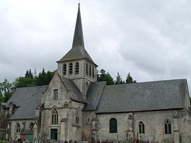 The church in Saint-Hymer | |
show Location of Saint-Hymer | |
 Saint-Hymer | |
| Coordinates: 49°15′15″N 0°10′27″E / 49.2542°N 0.1742°ECoordinates: 49°15′15″N 0°10′27″E / 49.2542°N 0.1742°E | |
| Country | France |
| Region | Normandy |
| Department | Calvados |
| Arrondissement | Lisieux |
| Canton | Pont-l'Évêque |
| Government | |
| • Mayor (2008–2014) | Pierre-Albert Cumont |
| Area 1 | 12.32 km2 (4.76 sq mi) |
| Population (Jan. 2018)[1] | 675 |
| • Density | 55/km2 (140/sq mi) |
| Time zone | UTC+01:00 (CET) |
| • Summer (DST) | UTC+02:00 (CEST) |
| INSEE/Postal code | 14593 /14130 |
| Elevation | 20–144 m (66–472 ft) (avg. 75 m or 246 ft) |
| 1 French Land Register data, which excludes lakes, ponds, glaciers > 1 km2 (0.386 sq mi or 247 acres) and river estuaries. | |


Saint-Hymer is a commune in the Calvados department in the Normandy region in northwestern France.
Population[]
| Year | Pop. | ±% |
|---|---|---|
| 1962 | 438 | — |
| 1968 | 459 | +4.8% |
| 1975 | 458 | −0.2% |
| 1982 | 502 | +9.6% |
| 1990 | 582 | +15.9% |
| 1999 | 663 | +13.9% |
| 2008 | 692 | +4.4% |
See also[]
- Communes of the Calvados department
References[]
- ^ "Populations légales 2018". INSEE. 28 December 2020.
| Wikimedia Commons has media related to Saint-Hymer. |
| show Communes of the Calvados department |
|---|
This Calvados geographical article is a stub. You can help Wikipedia by . |
Categories:
- Communes of Calvados (department)
- Calvados (department) geography stubs