Fauguernon
Fauguernon | |
|---|---|
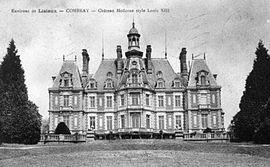 The chateau in Combray, at the start of the 20th century | |
 Coat of arms | |
show Location of Fauguernon | |
 Fauguernon | |
| Coordinates: 49°11′33″N 0°16′18″E / 49.1925°N 0.2717°ECoordinates: 49°11���33″N 0°16′18″E / 49.1925°N 0.2717°E | |
| Country | France |
| Region | Normandy |
| Department | Calvados |
| Arrondissement | Lisieux |
| Canton | Pont-l'Évêque |
| Intercommunality | CA Lisieux Normandie |
| Government | |
| • Mayor (2008–2014) | Serge Tougard |
| Area 1 | 7.41 km2 (2.86 sq mi) |
| Population (Jan. 2018)[1] | 248 |
| • Density | 33/km2 (87/sq mi) |
| Time zone | UTC+01:00 (CET) |
| • Summer (DST) | UTC+02:00 (CEST) |
| INSEE/Postal code | 14260 /14100 |
| Elevation | 68–167 m (223–548 ft) (avg. 150 m or 490 ft) |
| 1 French Land Register data, which excludes lakes, ponds, glaciers > 1 km2 (0.386 sq mi or 247 acres) and river estuaries. | |


show This article may be expanded with text translated from the corresponding article in French. (December 2008) Click [show] for important translation instructions. |
Fauguernon is a commune in the Calvados department in the Normandy region in northwestern France.
Population[]
| Year | Pop. | ±% |
|---|---|---|
| 1962 | 186 | — |
| 1968 | 139 | −25.3% |
| 1975 | 162 | +16.5% |
| 1982 | 153 | −5.6% |
| 1990 | 200 | +30.7% |
| 1999 | 182 | −9.0% |
| 2008 | 249 | +36.8% |
See also[]
- Communes of the Calvados department
References[]
- ^ "Populations légales 2018". INSEE. 28 December 2020.
| Wikimedia Commons has media related to Fauguernon. |
| show Communes of the Calvados department |
|---|
This Calvados geographical article is a stub. You can help Wikipedia by . |
Categories:
- Communes of Calvados (department)
- Calvados (department) geography stubs