Repentigny, Calvados
show This article may be expanded with text translated from the corresponding article in French. (December 2008) Click [show] for important translation instructions. |
Repentigny | |
|---|---|
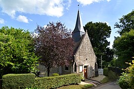 The church in Repentigny | |
show Location of Repentigny | |
 Repentigny | |
| Coordinates: 49°12′21″N 0°02′48″E / 49.2058°N 0.0467°ECoordinates: 49°12′21″N 0°02′48″E / 49.2058°N 0.0467°E | |
| Country | France |
| Region | Normandy |
| Department | Calvados |
| Arrondissement | Lisieux |
| Canton | Mézidon-Canon |
| Government | |
| • Mayor (2008–2014) | Maurice Davoust |
| Area 1 | 2.13 km2 (0.82 sq mi) |
| Population (Jan. 2018)[1] | 93 |
| • Density | 44/km2 (110/sq mi) |
| Time zone | UTC+01:00 (CET) |
| • Summer (DST) | UTC+02:00 (CEST) |
| INSEE/Postal code | 14533 /14340 |
| Elevation | 37–135 m (121–443 ft) (avg. 43 m or 141 ft) |
| 1 French Land Register data, which excludes lakes, ponds, glaciers > 1 km2 (0.386 sq mi or 247 acres) and river estuaries. | |


Repentigny is a commune in the Calvados department in the Normandy region in northwestern France.
Population[]
| Year | Pop. | ±% |
|---|---|---|
| 1962 | 57 | — |
| 1968 | 56 | −1.8% |
| 1975 | 51 | −8.9% |
| 1982 | 52 | +2.0% |
| 1990 | 69 | +32.7% |
| 1999 | 91 | +31.9% |
| 2008 | 89 | −2.2% |
See also[]
- Communes of the Calvados department
References[]
- ^ "Populations légales 2018". INSEE. 28 December 2020.
| Wikimedia Commons has media related to Repentigny (Calvados). |
| show Communes of the Calvados department |
|---|
This Calvados geographical article is a stub. You can help Wikipedia by . |
Categories:
- Communes of Calvados (department)
- Calvados (department) geography stubs