Barköl Kazakh Autonomous County
This article needs additional citations for verification. (September 2014) |
Barköl County
巴里坤县 باركۆل ناھىيىسى | |
|---|---|
| Barköl Kazakh Autonomous County 巴里坤哈萨克自治县 باركۆل قازاق ئاپتونوم ناھىيىسى باركول قازاق اۆتونوميالى اۋدانى Barkól Qazaq aýtonomııalyq aýdany | |
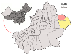 Location of Barköl County (red) within Hami City (yellow) and Xinjiang | |
| Coordinates: 43°35′56″N 93°01′01″E / 43.599°N 93.017°ECoordinates: 43°35′56″N 93°01′01″E / 43.599°N 93.017°E | |
| Country | People's Republic of China |
| Autonomous region | Xinjiang |
| Prefecture-level city | Hami |
| Time zone | UTC+8 (China Standard) |

Barköl Kazak Autonomous County (sometimes Barkul or Balikul in English) is part of Kumul Prefecture in Xinjiang and has an area of 38,445.3 km2 (14,843.8 sq mi). It forms part of the China–Mongolia border (bordering the Mongolian provinces of Khovd and Govi-Altai) on the county's north, while bordering Yizhou District to the south, Yiwu County to the east and Changji's Mori Kazakh Autonomous County to the west.
Barköl was made an autonomous county on October 1, 1954. It is noted for camel and horse breeding with the Barköl horse well known throughout China. Due to the large number of camels, which is unparalleled in China, the county is nicknamed of the "county of ten thousand camels".
Demographics[]
Lake Barkol[]
Lake Barkol or Barskul (Lake of Snow Leopard, بارسكۆل, Uyghur), is an alkali lake in a closed basin located at 43°40′05″N 92°48′11″E / 43.668°N 92.803°E. Current rainfall averages 210 millimetres (8.3 in), while the annual evaporation rate is 2,250 millimetres (89 in). Ancient shorelines show up as concentric rings on the satellite photo at right, indicating that water levels have varied many times in the past. One study identified five climates at Lake Barkol over the past 8,000 years, ranging from warm and wet to cold and wet and finally cold and dry at present. The average annual temperature in the area is now just 1 °C (34 °F), though temperatures swing from extreme highs (33.5 °C (92.3 °F)) to extreme lows (−43.6 °C (−46.5 °F)).[2]
References[]
- ^ 3-7 各地、州、市、县(市)分民族人口数 [3-7 Population by Nationality by Prefecture, State, City and County (City)]. tjj.xinjiang.gov.cn (in Chinese). Statistical Bureau of Xinjiang Uyghur Autonomous Region. 2020-06-10. Archived from the original on 2020-11-01. Retrieved 2021-06-11.
- ^ Barkol Lake, Xinjiang at Nasa Earth Observatory
| show Authority control |
|---|
This Xinjiang location article is a stub. You can help Wikipedia by . |
- Kazak autonomous counties
- Sites along the Silk Road
- Hami
- Xinjiang geography stubs