Carroll County, Tennessee
Carroll County | |
|---|---|
U.S. county | |
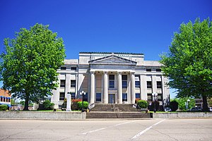 Carroll County Courthouse in Huntingdon | |
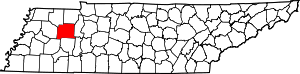 Location within the U.S. state of Tennessee | |
 Tennessee's location within the U.S. | |
| Coordinates: 35°59′N 88°27′W / 35.98°N 88.45°W | |
| Country | |
| State | |
| Founded | November 7, 1821 |
| Named for | William Carroll[1] |
| Seat | Huntingdon |
| Largest city | McKenzie |
| Area | |
| • Total | 600 sq mi (2,000 km2) |
| • Land | 599 sq mi (1,550 km2) |
| • Water | 0.8 sq mi (2 km2) 0.1%% |
| Population | |
| • Estimate (2018) | 28,020 |
| • Density | 48/sq mi (19/km2) |
| Time zone | UTC−6 (Central) |
| • Summer (DST) | UTC−5 (CDT) |
| Congressional district | 8th |
| Website | carrollcountytn |

Carroll County is a county located in the U.S. state of Tennessee. As of the 2010 census, the population was 28,522.[2] Its county seat is Huntingdon.[3] The county was established by the Tennessee General Assembly on November 7, 1821,[4] and was named for Governor William Carroll.[5]
Geography[]
According to the U.S. Census Bureau, the county has a total area of 600 square miles (1,600 km2), of which 599 square miles (1,550 km2) is land and 0.8 square miles (2.1 km2) (0.1%) is water.[6]
Adjacent counties[]
- Henry County (northeast)
- Benton County (east)
- Decatur County (southeast)
- Henderson County (south)
- Madison County (southwest)
- Gibson County (west)
- Weakley County (northwest)
State protected areas[]
- Harts Mill Wetland Wildlife Management Area (part)
- Jarrell Switch Refuge
- (part)
- Natchez Trace State Park (part)
Demographics[]
| Historical population | |||
|---|---|---|---|
| Census | Pop. | %± | |
| 1830 | 9,397 | — | |
| 1840 | 12,362 | 31.6% | |
| 1850 | 15,967 | 29.2% | |
| 1860 | 17,437 | 9.2% | |
| 1870 | 19,447 | 11.5% | |
| 1880 | 22,103 | 13.7% | |
| 1890 | 23,630 | 6.9% | |
| 1900 | 24,250 | 2.6% | |
| 1910 | 23,971 | −1.2% | |
| 1920 | 24,361 | 1.6% | |
| 1930 | 26,132 | 7.3% | |
| 1940 | 25,978 | −0.6% | |
| 1950 | 26,553 | 2.2% | |
| 1960 | 23,476 | −11.6% | |
| 1970 | 25,741 | 9.6% | |
| 1980 | 28,285 | 9.9% | |
| 1990 | 27,514 | −2.7% | |
| 2000 | 29,475 | 7.1% | |
| 2010 | 28,522 | −3.2% | |
| 2018 (est.) | 28,020 | [7] | −1.8% |
| U.S. Decennial Census[8] 1790-1960[9] 1900-1990[10] 1990-2000[11] 2010-2014[2] | |||

As of the census[13] of 2000, there were 29,475 people, 11,779 households, and 8,398 families residing in the county. The population density was 49 people per square mile (19/km2). There were 13,057 housing units at an average density of 22 per square mile (8/km2). The racial makeup of the county was 87.68% White, 10.35% Black or African American, 0.24% Native American, 0.16% Asian, 0.02% Pacific Islander, 0.45% from other races, and 1.10% from two or more races. 1.41% of the population were Hispanic or Latino of any race.
There were 11,779 households, out of which 30.00% had children under the age of 18 living with them, 56.30% were married couples living together, 11.50% had a female householder with no husband present, and 28.70% were non-families. 25.80% of all households were made up of individuals, and 12.70% had someone living alone who was 65 years of age or older. The average household size was 2.42 and the average family size was 2.90.
In the county, the population was spread out, with 23.20% under the age of 18, 8.40% from 18 to 24, 26.70% from 25 to 44, 24.40% from 45 to 64, and 17.30% who were 65 years of age or older. The median age was 39 years. For every 100 females there were 92.30 males. For every 100 females age 18 and over, there were 89.80 males.
The median income for a household in the county was $30,463, and the median income for a family was $36,880. Males had a median income of $29,904 versus $20,024 for females. The per capita income for the county was $16,251. About 10.90% of families and 13.90% of the population were below the poverty line, including 17.90% of those under age 18 and 13.40% of those age 65 or over.
Transportation[]
The Carroll County Airport is a county-owned public-use airport located four nautical miles (4.6 mi, 7.4 km) northwest of the central business district of Huntingdon, Tennessee.[14]
Media[]
Radio stations[]
- WRQR-FM 105.5 "Today's Best Music with Ace & TJ in the Morning"
- WTPR-AM 710 "The Greatest Hits of All Time"
- WTPR-FM 101.7 "The Greatest Hits of All Time"
- WEIO "100.9 The Farm"
- WHDM 1440-AM 98.9-FM
- WAJJ 89.3 FM Christian Radio "The J"
Newspapers[]
- The McKenzie Banner
- Carroll County News-Leader
- Tennessee Magnet Publications
Communities[]

City[]
- McKenzie (small portions in Henry County and Weakley County)
Towns[]
- Atwood
- Bruceton
- Clarksburg
- Hollow Rock
- Huntingdon (county seat)
- McLemoresville
- Trezevant
Unincorporated Communities[]
Politics[]

Carroll County is currently overwhelmingly Republican. Even before the rapid trend of the upland South away from the Democratic Party, Carroll was the northernmost county in the Unionist Republican bloc with Wayne, Henderson, Hardin and McNairy Counties within historically Democratic West Tennessee. This Unionist enclave was produced by the shallow, humus-poor and easily erodible Highland Rim soils, which were much less suitable for plantation farming than the rest of Middle and West Tennessee.[15]
See also[]
- National Register of Historic Places listings in Carroll County, Tennessee
References[]
- ^ Joe David McClure, "Carroll County," Tennessee Encyclopedia of History and Culture. Retrieved: 22 June 2013.
- ^ Jump up to: a b "State & County QuickFacts". United States Census Bureau. Archived from the original on July 8, 2011. Retrieved November 29, 2013.
- ^ "Find a County". National Association of Counties. Archived from the original on 2011-05-31. Retrieved 2011-06-07.
- ^ "TN Public Acts of 1821 Chapter 32". CTAS Private Acts. Retrieved 16 February 2017.
- ^ Gannett, Henry (1905). The Origin of Certain Place Names in the United States. Govt. Print. Off. pp. 70.
- ^ "2010 Census Gazetteer Files". United States Census Bureau. August 22, 2012. Retrieved April 2, 2015.
- ^ "Population and Housing Unit Estimates". Retrieved July 20, 2019.
- ^ "U.S. Decennial Census". United States Census Bureau. Retrieved April 2, 2015.
- ^ "Historical Census Browser". University of Virginia Library. Retrieved April 2, 2015.
- ^ Forstall, Richard L., ed. (March 27, 1995). "Population of Counties by Decennial Census: 1900 to 1990". United States Census Bureau. Retrieved April 2, 2015.
- ^ "Census 2000 PHC-T-4. Ranking Tables for Counties: 1990 and 2000" (PDF). United States Census Bureau. April 2, 2001. Retrieved April 2, 2015.
- ^ Based on 2000 census data
- ^ "U.S. Census website". United States Census Bureau. Retrieved 2011-05-14.
- ^ FAA Airport Form 5010 for HZD PDF. Federal Aviation Administration. Effective 30 June 2011.
- ^ Wright, John K.; ‘Voting Habits in the United States: A Note on Two Maps’; Geographical Review, vol. 22, no. 4 (October 1932), pp. 666-672
- ^ Leip, David. "Dave Leip's Atlas of U.S. Presidential Elections". uselectionatlas.org. Retrieved 2018-03-10.
Further reading[]
- History of Carroll County Tennessee. Nashville: Turner Publishing (1987). ISBN 0-938021-01-X
External links[]
| Wikimedia Commons has media related to Carroll County, Tennessee. |
- Carroll County Chamber of Commerce
- Carroll County, TNGenWeb - free genealogy resources for the county
- Carroll County at Curlie
| show Places adjacent to Carroll County, Tennessee |
|---|
| show Municipalities and communities of Carroll County, Tennessee, United States |
|---|

Coordinates: 35°59′N 88°27′W / 35.98°N 88.45°W
| show Authority control |
|---|
- Tennessee counties
- Carroll County, Tennessee
- 1821 establishments in Tennessee
- Populated places established in 1821