DeKalb County, Tennessee
DeKalb County | |
|---|---|
U.S. county | |
 Dekalb County Courthouse in Smithville | |
 Location within the U.S. state of Tennessee | |
 Tennessee's location within the U.S. | |
| Coordinates: 35°59′N 85°50′W / 35.98°N 85.83��W | |
| Country | |
| State | |
| Founded | 1837 |
| Named for | Johann de Kalb[1] |
| Seat | Smithville |
| Largest city | Smithville |
| Area | |
| • Total | 329 sq mi (850 km2) |
| • Land | 304 sq mi (790 km2) |
| • Water | 25 sq mi (60 km2) 7.5%% |
| Population (2010) | |
| • Total | 18,723 |
| • Density | 62/sq mi (24/km2) |
| Time zone | UTC−6 (Central) |
| • Summer (DST) | UTC−5 (CDT) |
| Congressional district | 6th |
| Website | dekalbtennessee |

DeKalb County is a county located in the U.S. state of Tennessee. As of the 2010 census, the population was 18,723.[2] Its county seat is Smithville.[3] The county was created by the General Assembly of Tennessee on December 2, 1837 and was named for Revolutionary War hero Major General Johann de Kalb.[4]
History[]
DeKalb County was formed in 1837 from land in Cannon, Warren and White counties. Historian believes that the first settlers in the county were at Liberty and came from Maryland in 1797.[5] If so, Addison Puckett was the first settler. She may have come over the Cumberland Mountains, although some sources claim she came down the Ohio, up the Cumberland to Nashville, and then overland about 69 miles.[5]
DeKalb County was the site of several saltpeter mines, the main ingredient of gunpowder, and was obtained by leaching the earth from several local caves. Overall Cave was named for Abraham Overall who moved from Luray, Virginia, and settled near the present site of Liberty in 1805. He reportedly had many slaves and owned a large plantation on which Overall Cave is located. Two saltpeter leaching vats in the cave may date from the War of 1812, although this area was mined again during the Civil War. Other caves in DeKalb County that were mined for saltpeter include Avant Cave, located near Dowelltown, Indian Grave Point Cave, located in the Dry Creek Valley, and Temperance Saltpeter Cave, located near Temperance Hall.[6]
Geography[]

According to the U.S. Census Bureau, the county has a total area of 329 square miles (850 km2), of which 304 square miles (790 km2) is land and 25 square miles (65 km2) (7.5%) is water.[7]
Adjacent counties[]
- Putnam County (northeast)
- White County (east)
- Warren County (south)
- Cannon County (southwest)
- Wilson County (west)
- Smith County (northwest)
State protected areas[]
- Edgar Evins State Park
- Pea Ridge Wildlife Management Area
Demographics[]
| Historical population | |||
|---|---|---|---|
| Census | Pop. | %± | |
| 1840 | 5,868 | — | |
| 1850 | 8,016 | 36.6% | |
| 1860 | 10,573 | 31.9% | |
| 1870 | 11,425 | 8.1% | |
| 1880 | 14,813 | 29.7% | |
| 1890 | 15,650 | 5.7% | |
| 1900 | 16,460 | 5.2% | |
| 1910 | 15,434 | −6.2% | |
| 1920 | 15,370 | −0.4% | |
| 1930 | 14,213 | −7.5% | |
| 1940 | 14,588 | 2.6% | |
| 1950 | 11,680 | −19.9% | |
| 1960 | 10,774 | −7.8% | |
| 1970 | 11,151 | 3.5% | |
| 1980 | 13,589 | 21.9% | |
| 1990 | 14,360 | 5.7% | |
| 2000 | 17,423 | 21.3% | |
| 2010 | 18,723 | 7.5% | |
| 2018 (est.) | 20,138 | [8] | 7.6% |
| U.S. Decennial Census[9] 1790-1960[10] 1900-1990[11] 1990-2000[12] 2010-2014[2] | |||
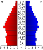
As of the census[14] of 2000, there were 17,423 people, 6,984 households, and 4,986 families residing in the county. The population density was 57 people per square mile (22/km2). There were 8,409 housing units at an average density of 28 per square mile (11/km2). The racial makeup of the county was 95.58% White, 1.43% Black or African American, 0.28% Native American, 0.14% Asian, 0.02% Pacific Islander, 1.62% from other races, and 0.94% from two or more races. 3.63% of the population were Hispanic or Latino of any race.
There were 6,984 households, out of which 30.10% had children under the age of 18 living with them, 56.10% were married couples living together, 11.10% had a female householder with no husband present, and 28.60% were non-families. 25.50% of all households were made up of individuals, and 10.70% had someone living alone who was 65 years of age or older. The average household size was 2.45 and the average family size was 2.90.
In the county, the population was spread out, with 23.30% under the age of 18, 8.50% from 18 to 24, 29.30% from 25 to 44, 24.60% from 45 to 64, and 14.30% who were 65 years of age or older. The median age was 38 years. For every 100 females there were 97.70 males. For every 100 females age 18 and over, there were 94.90 males.
The median income for a household in the county was $30,359, and the median income for a family was $36,920. Males had a median income of $29,483 versus $20,953 for females. The per capita income for the county was $17,217. About 11.80% of families and 17.00% of the population were below the poverty line, including 20.00% of those under age 18 and 20.10% of those age 65 or over.
Communities[]
City[]
- Smithville (county seat)
Towns[]
Unincorporated communities[]
Education[]
The DeKalb County School System consists of five public schools and an adult education center.[15]
- DeKalb County High School (9-12) – opened 1963
- DeKalb Middle School (6-8) – opened 1971
- DeKalb West School (PK-8) – opened 1973
- Northside Elementary School (2-5) – opened 2000
- Smithville Elementary School (PK-2) – opened 1958
DeKalb County operated two high schools from the 1920s to 1963, Liberty High School and Smithville High School (originally Pure Fountain High School and later DeKalb County High School). In January 1962, Smithville High School burned down, and the present high school was constructed in a different part of town. When the school opened, Liberty High was closed and it was consolidated with DeKalb County beginning in September 1963.[16]
Politics[]
DeKalb County is a Republican stronghold. The last Democrat to carry this county was Al Gore in 2000. Even before the rapid trend of the upland South away from the Democratic Party, DeKalb County was unusual for Middle Tennessee as it had significant Unionist sympathy[17] and was a competitive county for the GOP even at the height of the “Solid South” era.
See also[]
- National Register of Historic Places listings in DeKalb County, Tennessee
References[]
- ^ Thomas G. Webb, "Dekalb County," Tennessee Encyclopedia of History and Culture. Retrieved: 26 June 2013.
- ^ Jump up to: a b "State & County QuickFacts". United States Census Bureau. Archived from the original on June 7, 2011. Retrieved November 29, 2013.
- ^ "Find a County". National Association of Counties. Archived from the original on 2011-05-31. Retrieved 2011-06-07.
- ^ Gannett, Henry (1905). The Origin of Certain Place Names in the United States. Govt. Print. Off. pp. 103.
- ^ Jump up to: a b Hale, Will T. History of Dekalb County, Tennessee. Nashville, P. Hunter, 1915. 254 pp. (reprinted McMinnville, B. Lomond Press, 1969).
- ^ Thomas C. Barr, Jr., "Caves of Tennessee", Bulletin 64 of the Tennessee Division of Geology, 1961, 568 pages.
- ^ "2010 Census Gazetteer Files". United States Census Bureau. August 22, 2012. Retrieved April 4, 2015.
- ^ "Population and Housing Unit Estimates". Retrieved December 26, 2019.
- ^ "U.S. Decennial Census". United States Census Bureau. Retrieved April 4, 2015.
- ^ "Historical Census Browser". University of Virginia Library. Retrieved April 4, 2015.
- ^ Forstall, Richard L., ed. (March 27, 1995). "Population of Counties by Decennial Census: 1900 to 1990". United States Census Bureau. Retrieved April 4, 2015.
- ^ "Census 2000 PHC-T-4. Ranking Tables for Counties: 1990 and 2000" (PDF). United States Census Bureau. April 2, 2001. Retrieved April 4, 2015.
- ^ Based on 2000 census data
- ^ "U.S. Census website". United States Census Bureau. Retrieved 2011-05-14.
- ^ https://www.wjleradio.com/archives/architect-study-recommends-replacing-repurposing-smithville-elementary-school-view-options-for-each-school-here/
- ^ https://www.wjleradio.com/archives/dchs-class-of-1964-celebrates-50th-year-reunion/
- ^ Crofts, Danield W.; Reluctant Confederates Upper South Unionists in the Secession Crisis, p. 347 ISBN 1469617013
- ^ Leip, David. "Dave Leip's Atlas of U.S. Presidential Elections". uselectionatlas.org. Retrieved 2018-03-10.
External links[]
| Wikimedia Commons has media related to DeKalb County, Tennessee. |
- Official site
- Smithville-DeKalb County Chamber of Commerce
- DeKalb County Schools
- DeKalb County, TNGenWeb – genealogy resources
- DeKalb County at Curlie
| show Places adjacent to DeKalb County, Tennessee |
|---|
| show Municipalities and communities of DeKalb County, Tennessee, United States |
|---|

Coordinates: 35°59′N 85°50′W / 35.98°N 85.83°W
| show Authority control |
|---|
- Tennessee counties
- DeKalb County, Tennessee
- 1837 establishments in Tennessee
- Populated places established in 1837
- Counties of Appalachia