Fentress County, Tennessee
Fentress County | |
|---|---|
U.S. county | |
 Fentress County Courthouse in Jamestown | |
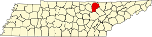 Location within the U.S. state of Tennessee | |
 Tennessee's location within the U.S. | |
| Coordinates: 36°22′50″N 84°55′57″W / 36.3804934°N 84.9324585°WCoordinates: 36°22′50″N 84°55′57″W / 36.3804934°N 84.9324585°W | |
| Country | |
| State | |
| Founded | November 28, 1823 |
| Named for | James Fentress, state legislator[1] |
| Seat | Jamestown |
| Largest city | Jamestown |
| Government | |
| • County Executive | Jimmy Johnson |
| Area | |
| • Total | 499 sq mi (1,290 km2) |
| • Land | 499 sq mi (1,290 km2) |
| • Water | 0.3 sq mi (0.8 km2) 0.06%% |
| Population | |
| • Estimate (2018) | 18,217 |
| • Density | 36/sq mi (14/km2) |
| Time zone | UTC−6 (Central) |
| • Summer (DST) | UTC−5 (CDT) |
| Congressional district | 6th |
| Website | www |
| [2][3] | |

Fentress County is a county located in the U.S. state of Tennessee. As of the 2010 census, the population was 17,959.[4] Its county seat is Jamestown.[5]
History[]
Fentress County was formed on November 28, 1823 from portions of Morgan, Overton and White counties.[3] The resulting county was named for James Fentress[6] (1763–1843), who served as speaker of the state house, chairman of Montgomery County Court, and commissioner to select seats for Haywood, Carroll, Gibson and Weakley counties in West Tennessee.[1]
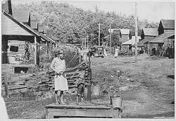
Fentress County was the site of several saltpeter mines. Saltpeter is the main ingredient of gunpowder and was obtained by leaching the earth from local caves. The largest mine was in York Cave, near the Wolf River Post Office. At one time, twenty-five large leaching vats were in operation in this cave. According to Barr (1961) this cave was mined during the Civil War. Buffalo Cave near Jamestown was also a major mine with twelve leaching vats. Manson Saltpeter Cave in Big Indian Creek Valley was a smaller operation with four leaching vats. These caves may also have been mined during the War of 1812, as saltpeter mining was widespread in Kentucky and Tennessee during that era.[7]
In the runup to the American Civil War, when Tennessee Governor Harris asked the State Legislature for a vote of secession, the two representatives from Fentress County (Reese T. Hildreth and R. H. Bledsoe) voted for Secession.
Alvin York (1887–1964), a hero at the Meuse-Argonne Offensive during World War I, was born and lived in Fentress County. He established the Alvin C. York Agricultural Institute in Jamestown in 1924.[8] York's house and farm are part of Sgt. Alvin C. York State Historic Park in Pall Mall.
County Officials[]
County Sheriff: Michael Reagon
County Register of Deeds: Trish Slaven
County Road Supervisor: Joey Reagan
County Property Assessor: Melynda Sullivan
County Trustee: Angie Sweet
Circuit Court Clerk: Gina Miller
County Clerk: Marylin Stephens
County Emergency Management Director: James Bilbrey
County 911 Director: Richard Cross
County Fire Chief: Scott King
County Emergency Services Director: Micah Dunford
County Finance Director: Tyler Arms
Clerk and Master: Linda Smith
Election Commission Director: Joey Williams
General Sessions Judge: Todd Burnett
Solid Waste Director: Jackie Selby
Library Director: Donna Conatser
Geography[]
According to the U.S. Census Bureau, the county has a total area of 499 square miles (1,290 km2), of which 499 square miles (1,290 km2) is land and 0.3 square miles (0.78 km2) (0.06%) is water.[9]
Fentress County includes part of Dale Hollow Reservoir and is drained by forks of the Obey and Cumberland Rivers.
The county is the easternmost county in the United States to observe Central Time.
Adjacent counties[]

- Pickett County (north)
- Scott County (east/EST Border)
- Morgan County (southeast/EST Border)
- Cumberland County (south)
- Overton County (west)
- Putnam County (southwest)
National protected area[]
State protected areas[]
- Catoosa Wildlife Management Area (part)
- Colditz Cove State Natural Area
- (part)
- Pogue Creek State Natural Area
- (part)
- Sgt. Alvin C. York State Historic Park
- Skinner Mountain Wildlife Management Area
- Twin Arches State Natural Area (part)
Demographics[]
| Historical population | |||
|---|---|---|---|
| Census | Pop. | %± | |
| 1830 | 2,748 | — | |
| 1840 | 3,550 | 29.2% | |
| 1850 | 4,454 | 25.5% | |
| 1860 | 5,054 | 13.5% | |
| 1870 | 4,717 | −6.7% | |
| 1880 | 5,941 | 25.9% | |
| 1890 | 5,226 | −12.0% | |
| 1900 | 6,106 | 16.8% | |
| 1910 | 7,446 | 21.9% | |
| 1920 | 10,435 | 40.1% | |
| 1930 | 11,036 | 5.8% | |
| 1940 | 14,262 | 29.2% | |
| 1950 | 14,917 | 4.6% | |
| 1960 | 13,288 | −10.9% | |
| 1970 | 12,593 | −5.2% | |
| 1980 | 14,826 | 17.7% | |
| 1990 | 14,669 | −1.1% | |
| 2000 | 16,625 | 13.3% | |
| 2010 | 17,958 | 8.0% | |
| 2018 (est.) | 18,217 | [10] | 1.4% |
| U.S. Decennial Census[11] 1790-1960[12] 1900-1990[13] 1990-2000[14] 2010-2014[4] | |||
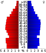
As of the 2010 census,[16] there were 17,959 people, 7,326 households, and 4,818 families residing in the county. The population density was 36 people per square mile (13/km2). There were 8,927 housing units at an average density of 15 per square mile (6/km2). The racial makeup of the county was 98.1% White, 0.2% Black or African American, 0.2% Native American, 0.2% Asian, 0.4% from other races, and 0.9% from two or more races. 1.1% of the population were Hispanic or Latino of any race.
In the county's 7,326 households, 23.1% had children under the age of 18, 57.30% were married couples living together, 11.30% had a female householder with no husband present, and 28.00% were non-families. 25.50% of all households were made up of individuals, and 11.10% had someone living alone who was 65 years of age or older. The average household size was 2.46 and the average family size was 2.94.
In the county, the population was spread out, with 24.20% under the age of 18, 8.00% from 18 to 24, 28.10% from 25 to 44, 26.10% from 45 to 64, and 13.70% who were 65 years of age or older. The median age was 38 years. For every 100 females there were 96.20 males. For every 100 females age 18 and over, there were 93.10 males.
The median income for a household in the county was $23,238, and the median income for a family was $28,856. Males had a median income of $23,606 versus $18,729 for females. The per capita income for the county was $12,999. 19.50% of families and 23.10% of the population were below the poverty line, including 27.80% of those under age 18 and 20.50% of those over age 64.
Communities[]
Cities[]
Census-designated places[]
Unincorporated communities[]
Politics[]
Like most of East Tennessee, Fentress County has been heavily Republican since the Civil War. Since then, only two Democrats, southerners Jimmy Carter in 1976 and Bill Clinton in 1992 and 1996 have carried Fentress County.
See also[]
References[]
- ^ Jump up to: a b Lorene Cargile, "Fentress County," Tennessee Encyclopedia of History and Culture. Retrieved: June 27, 2013.
- ^ "Fentress County". Geographic Names Information System. United States Geological Survey. August 1, 1991.
- ^ Jump up to: a b "County Formation in Acts of Tennessee: Fentress County". Tennessee State Library and Archives. Retrieved January 17, 2021.
- ^ Jump up to: a b "State & County QuickFacts". United States Census Bureau. Archived from the original on June 7, 2011. Retrieved November 29, 2013.
- ^ "Find a County". National Association of Counties. Archived from the original on May 31, 2011. Retrieved June 7, 2011.
- ^ Gannett, Henry (1905). The Origin of Certain Place Names in the United States. Govt. Print. Off. p. 125.
- ^ Thomas C. Barr, Jr., "Caves of Tennessee", Bulletin 64 of the Tennessee Division of Geology, 1961.
- ^ Alvin C. York Institute website. Retrieved June 27, 2013.
- ^ "2010 Census Gazetteer Files". United States Census Bureau. August 22, 2012. Retrieved April 4, 2015.
- ^ "Population and Housing Unit Estimates". Retrieved July 20, 2019.
- ^ "U.S. Decennial Census". United States Census Bureau. Retrieved April 4, 2015.
- ^ "Historical Census Browser". University of Virginia Library. Retrieved April 4, 2015.
- ^ Forstall, Richard L., ed. (March 27, 1995). "Population of Counties by Decennial Census: 1900 to 1990". United States Census Bureau. Retrieved April 4, 2015.
- ^ "Census 2000 PHC-T-4. Ranking Tables for Counties: 1990 and 2000" (PDF). United States Census Bureau. April 2, 2001. Retrieved April 4, 2015.
- ^ Based on 2000 census data
- ^ "U.S. Census website". United States Census Bureau. Retrieved May 14, 2011.
- ^ Leip, David. "Dave Leip's Atlas of U.S. Presidential Elections". uselectionatlas.org. Retrieved March 10, 2018.
Further reading[]
- Duke, Jason. Tennessee Coal Mining, Railroading & Logging in Cumberland, Fentress, Overton & Putnam. Nashville: Turner Publishing (2004). ISBN 1-56311-932-3
- Hogue, Albert R. History of Fentress County, Tennessee. Santa Maria: Janaway Publishing (2010). ISBN 1-59641-220-8
- Hogue, Albert R. History of Fentress County, Tennessee; The Old Home of Mark Twain's Ancestors. Memphis: General Books (2010). ISBN 1-150-82647-9
External links[]
| Wikimedia Commons has media related to Fentress County, Tennessee. |
- Official website

- Fentress County Chamber of Commerce
- Fentress County Schools
- Fentress County, TNGenWeb – genealogy resources
- Fentress County Landforms
- Fentress County at Curlie
| show Places adjacent to Fentress County, Tennessee |
|---|
| show Municipalities and communities of Fentress County, Tennessee, United States |
|---|

| show Authority control |
|---|
- Tennessee counties
- Fentress County, Tennessee
- 1823 establishments in Tennessee
- Counties of Appalachia
- Populated places established in 1823