Cerisy-la-Forêt
This article needs additional citations for verification. (January 2018) |
This article is a rough translation from French. It may have been generated by a computer or by a translator without dual proficiency. |
Cerisy-la-Forêt | |
|---|---|
 The abbey in Cerisy-la-Forêt | |
show Location of Cerisy-la-Forêt | |
 Cerisy-la-Forêt | |
| Coordinates: 49°11′45″N 0°56′08″W / 49.1958°N 0.9356°WCoordinates: 49°11′45″N 0°56′08″W / 49.1958°N 0.9356°W | |
| Country | France |
| Region | Normandy |
| Department | Manche |
| Arrondissement | Saint-Lô |
| Canton | Pont-Hébert |
| Intercommunality | Saint-Lô Agglo |
| Government | |
| • Mayor (2020–2026) | Jean-Pierre Ledouit |
| Area 1 | 23.81 km2 (9.19 sq mi) |
| Population (Jan. 2018)[1] | 1,031 |
| • Density | 43/km2 (110/sq mi) |
| Time zone | UTC+01:00 (CET) |
| • Summer (DST) | UTC+02:00 (CEST) |
| INSEE/Postal code | 50110 /50680 |
| Elevation | 34–131 m (112–430 ft) (avg. 84 m or 276 ft) |
| 1 French Land Register data, which excludes lakes, ponds, glaciers > 1 km2 (0.386 sq mi or 247 acres) and river estuaries. | |


Cerisy-la-Forêt (French pronunciation: [səʁizi la fɔʁɛ]) is a commune in the Manche department of Normandy in north-western France. It has a population of 1,034 inhabitants and possesses an important environmental and architectural heritage.
The area has been occupied since antiquity and is linked to the foundation of the Saint-Vigor Abbey in the early 20th century. The 2,300 ha commune comprises several castles (Château de la Boulaye, Château de la Couespellière) and manor houses and is bordered by Cerisy forest.
Geography[]
The commune is located in the department of Manche, north of the Armorican Massif, east of the and west of Bessin. The village is located 13.4 km northeast of Saint-Lô, overlooking the valley of the Elle, and offering an unobstructed panorama over the Cerisy Forest a kilometer away. The Massif Armoricain, of which Cerisy-la-Forêt occupies the extreme north, is a country of dairy farms. The landscapes are composed of meadows, hedges, wooded areas and wetlands. The nearest stations are Gare de Lison and Gare de Le Molay-Littry.
Bayeux is 18 km east as the crow flies, Saint-Lô, prefecture of the department, 14 km to the south-west, and Caen 42 km to the east.[2]
Geology[]
The Armorican Massif, to the southwest, is a deposit made up of clays, schists, gravels, and granite. The altitude of the village is between 34 meters and 131 meters.[3] The highest point corresponds to the place called "Vieux Graviers", a small hill located at the edge of Cerisy-la-Forêt.
The subsoil of Cerisy-la-Forêt dates from the Proterozoic geological period.
Climate[]
The climate is oceanic, with an annual rainfall close to 900 mm.[4] Rains are fairly frequent throughout the year but more abundant in autumn and winter due to disturbances from the Atlantic Ocean. Rarely intense, they are often drizzles.
The average temperature is 10 °C.[5] In winter, the average temperature oscillates between 1 °C and 7 °C. There are between 30 and 40 days of frost per year. In summer, the average temperature is around 20 °C.
Cerisy-la-Forêt does not have a weather station; the closest one is that of Caen-Carpiquet.
Name[]

'Cerisy-la-Forêt' is often referred to as 'Cerisy'. The name is derived from the Latin cerasus "cherry",[6] though Auguste Vincent holds it is named for a Gallo-Roman by the name Carisius or Charisius[7]
History[]
Ancient history[]
Cerisy was first settled as an oppidum, the ruins of which remain outside the town.[8] The Romans built a fort to guard the Roman road that ran through the valley.[9][10][11]
Middle Ages[]
The earliest mention of Cerisy-la-Forêt dates back to the 6th century, when Gaul began to Christianize. Vigor, one of the first evangelists in the region, received from Volusian, the local lord, twenty-five villages, to thank him for having rid the region of a "horrible serpent that put to death men and animals". Around 510 AD he built a monastery dedicated to St. Peter and St. Paul on the site of what had been a Druid holy site.
In the 9th century, Neustria was invaded by the Vikings, who in 891 plundered Bayeux, and Vigor's monastery was destroyed. King Charles III the Simple gave Rollo the countries of the lower Seine in the Treaty of Saint-Clair-sur-Epte in 911, and then Bessin in 924.[12]
Cerisy became an important market town under the Normans, who build Cerisy Abbey. The abbey went on to consist of forty-eight parishes and eight priories, including two in England, (Sherborne and Peterborough). Dependent on the Holy See, Cerisy maintained close relations with monasteries in Mont-Saint-Michel, Saint-Ouen, Jumièges, Le Bec-Hellouin, Fécamp and of course Caen.
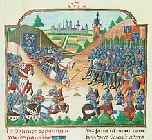
In 1337, the dynastic rivalries between the Valois and the king of England precipitated the Hundred Years' War, which plunged the country into misery, aggravated by epidemics of plague. The Abbey of Saint-Vigor de Cerisy was fortified, and a garrison settled there. In 1418, Richard de Silly, knight and captain of the abbey, was obliged to cede the abbey to the King of England. However, after the victory of the constable de Richemont over the English at the Battle of Formigny in 1450, Normandy returned definitively to the kingdom of France.
Modern history[]

In 1660, a maréchaussée garrison was based in the village, and a prison established.[13]
During the Second World War, Cerisy-la-Forêt sheltered refugees from Cherbourg.[14] On July 2, 1944, General Eisenhower and Omar Bradley came to encourage the 2nd American infantry division "Indian head" at the .

On June 12, 1944, the 2nd American infantry division was ordered to cross the river. When they reached the east bank, they encountered enemy resistance, which foreshadowed the end of the rapid advance begun on June 7, 1944. It was a small easily crossed river, but its crossing was difficult. A first attempt was stopped by machine-gun and mortar fire from the west bank. On June 13, 1944, the men of Company C of the 38th Infantry Regiment were ordered to cross the river at this point. The first attempt in the morning failed and it was only in the afternoon after the second offensive[clarification needed] that they succeeded in reaching the other bank.
The fighting resulted in numerous casualties, ten men of Company C were killed and 23 others wounded. In total, the losses of the 2nd American Infantry Division during the two days of combat amounted to 540 killed, wounded or disappeared.
During the second attack of Company C on June 13, 1944, the men were stopped by machine gun fire. Enemy mortars began to adjust their fire on the GIs. Advancing under mortars, the men of the C Company won the battle.[15]
Gallery[]

Cerisy-la-Forêt, rue halles (1920)

Chateau de l'Abbaye

Cerisy-la-Forêt schools 1900

Liberation of Cerisy Nouveau

Eugène Godin.


Population[]
|
| ||||||||||||||||||||||||||||||||||||||||||||||||||||||||||||||||||||||||||||||||||||||||||||||||||||||||||||||||||
| Source: EHESS[16] and INSEE (1968-2017)[17] | |||||||||||||||||||||||||||||||||||||||||||||||||||||||||||||||||||||||||||||||||||||||||||||||||||||||||||||||||||
See also[]
- Communes of the Manche department
References[]
- ^ "Populations légales 2018". INSEE. 28 December 2020.
- ^ CERISY-LA-FORET Code INSEE - 50110 [archive], sur Géoportail, le portail des territoires et des citoyens (consulté le 26 mai 2012).
- ^ "PLAN CERISY-LA-FORET - Plan, carte et relief de Cerisy-la-Forêt 50680 ou 50810". www.cartesfrance.fr. Retrieved 2020-04-24.
- ^ https://web.archive.org/web/20110223121820/http://www.basse-normandie.ecologie.gouv.fr/iso_album/pluvio_inter_4.jpg
- ^ "Archived copy". Archived from the original on 2020-04-14. Retrieved 2017-04-23.CS1 maint: archived copy as title (link)
- ^ Auguste Longnon, Les noms de lieux de la France, Paris, 1920–1929; rééd. Champion, Paris, 1979, p. 625, § 2949.
- ^ Auguste Vincent, Toponymie de la France, Bruxelles, 1937, p. 74b, § 180.
- ^ L'oppidum de Saint-Jean-de-Savigny
- ^ Thomas Blanc-Dumont, Contribution à la caractérisation du type d’occupation des sols à partir des propriétés magnétiques : cas des sites de Montfarville et de Cerisy-la-Forêt (Basse Normandie)(Sous la direction de Marie Pétronille et Alain Tabbagh, 2006).
- ^ Histoire de l'Académie royale des inscriptions et belles lettres, 28, (Paris, 1761) p480.
- ^ Cerisy-la-Forêt - L'abbatiale Archived 2016-03-03 at the Wayback Machine.
- ^ Abbaye de Cerisy [archive].
- ^ Jean Bigot sieur de Sommesnil, État des paroisses des élections de Normandie, 1612/1636
- ^ Ina » [archive].
- ^ https://www.militarytimes.com/error-404.
- ^ Des villages de Cassini aux communes d'aujourd'hui: Commune data sheet Cerisy-la-Forêt, EHESS. (in French)
- ^ Population en historique depuis 1968, INSEE
| Wikimedia Commons has media related to Cerisy-la-Forêt. |
| show Communes of Manche |
|---|
| show Authority control |
|---|
- Communes of Manche