Fermanville
Fermanville | |
|---|---|
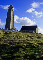 The Cape Lévi lighthouse | |
show Location of Fermanville | |
 Fermanville | |
| Coordinates: 49°41′08″N 1°27′13″W / 49.6856°N 1.4536°WCoordinates: 49°41′08″N 1°27′13″W / 49.6856°N 1.4536°W | |
| Country | France |
| Region | Normandy |
| Department | Manche |
| Arrondissement | Cherbourg |
| Canton | Val-de-Saire |
| Intercommunality | CA Cotentin |
| Government | |
| • Mayor (2020–2026) | Nicole Belliot-Delacour[1] |
| Area 1 | 11.60 km2 (4.48 sq mi) |
| Population (Jan. 2018)[2] | 1,274 |
| • Density | 110/km2 (280/sq mi) |
| Time zone | UTC+01:00 (CET) |
| • Summer (DST) | UTC+02:00 (CEST) |
| INSEE/Postal code | 50178 /50840 |
| Elevation | 0–136 m (0–446 ft) (avg. 50 m or 160 ft) |
| 1 French Land Register data, which excludes lakes, ponds, glaciers > 1 km2 (0.386 sq mi or 247 acres) and river estuaries. | |


Fermanville is a commune in the Manche department in north-western France.
French submarine Prométhée sank off Fermanville on 7 July 1932.
Places of interest[]

Fermanville Viaduct

Fort Lévi.
- Fort Lévi : fort built in 1801 on Napoleon's orders ;
- Railway viaduct located in the vallée des moulins village, used until 1951 for the Cherbourg-Barfleur train ;
See also[]
- Communes of the Manche department
References[]
- ^ "Répertoire national des élus: les maires". data.gouv.fr, Plateforme ouverte des données publiques françaises (in French). 2 December 2020.
- ^ "Populations légales 2018". INSEE. 28 December 2020.
External links[]
| Wikimedia Commons has media related to Fermanville. |
- Fermanville official website (in French)
| show Communes of Manche |
|---|
| show Authority control |
|---|
This Manche geographical article is a stub. You can help Wikipedia by . |
Categories:
- Communes of Manche
- Manche geography stubs