Gacé
Gacé | |
|---|---|
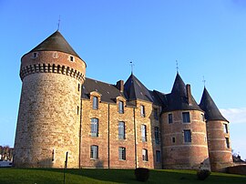 Gacé Castle (fr. Château de Gacé) | |
show Location of Gacé | |
 Gacé | |
| Coordinates: 48°47′38″N 0°17′52″E / 48.7939°N 0.2978°ECoordinates: 48°47′38″N 0°17′52″E / 48.7939°N 0.2978°E | |
| Country | France |
| Region | Normandy |
| Department | Orne |
| Arrondissement | Mortagne-au-Perche |
| Canton | Vimoutiers |
| Intercommunality | |
| Government | |
| • Mayor (2014-2020) | François Dreux |
| Area 1 | 6.5 km2 (2.5 sq mi) |
| Population (Jan. 2018)[1] | 1,836 |
| • Density | 280/km2 (730/sq mi) |
| Time zone | UTC+01:00 (CET) |
| • Summer (DST) | UTC+02:00 (CEST) |
| INSEE/Postal code | 61181 /61230 |
| Elevation | 179–316 m (587–1,037 ft) (avg. 186 m or 610 ft) |
| Website | www.gace.fr |
| 1 French Land Register data, which excludes lakes, ponds, glaciers > 1 km2 (0.386 sq mi or 247 acres) and river estuaries. | |


Gacé is a commune in the Orne department in Lower-Normandy, north-western France.
Population[]
| Year | Pop. | ±% |
|---|---|---|
| 2004 | 2,140 | — |
| 2006 | 2,130 | −0.5% |
| 2007 | 2,110 | −0.9% |
| 2008 | 2,088 | −1.0% |
| 2009 | 2,065 | −1.1% |
| 2010 | 2,102 | +1.8% |
| 2011 | 2,099 | −0.1% |
| 2012 | 2,031 | −3.2% |
| 2013 | 1,966 | −3.2% |
| 2014 | 1,901 | −3.3% |
| 2015 | 1,896 | −0.3% |
| 2016 | 1,886 | −0.5% |
Heraldry[]
 |
The arms of Gacé are blazoned: Argent, a lion gules, crowned Or, langued azure.
|
Administration[]

City Hall in the Castle
Twin towns[]
 Kinross, Perth & Kinross, Scotland
See also[]
- Communes of the Orne department
- Château de Gacé
References[]
- ^ "Populations légales 2018". INSEE. 28 December 2020.
| Wikimedia Commons has media related to Gacé. |
| show Communes of the Orne department |
|---|
This Orne geographical article is a stub. You can help Wikipedia by . |
Categories:
- Communes of Orne
- Orne geography stubs