Mortrée
Mortrée | |
|---|---|
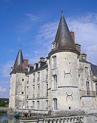 The chateau in Mortrée | |
show Location of Mortrée | |
 Mortrée | |
| Coordinates: 48°38′25″N 0°04′44″E / 48.6403°N 0.0789°ECoordinates: 48°38′25″N 0°04′44″E / 48.6403°N 0.0789°E | |
| Country | France |
| Region | Normandy |
| Department | Orne |
| Arrondissement | Alençon |
| Canton | Sées |
| Intercommunality | Sources de l'Orne |
| Government | |
| • Mayor (2020–2026) | Marc Richard[1] |
| Area 1 | 32.26 km2 (12.46 sq mi) |
| Population (Jan. 2018)[2] | 1,160 |
| • Density | 36/km2 (93/sq mi) |
| Time zone | UTC+01:00 (CET) |
| • Summer (DST) | UTC+02:00 (CEST) |
| INSEE/Postal code | 61294 /61570 |
| Elevation | 161–277 m (528–909 ft) (avg. 173 m or 568 ft) |
| 1 French Land Register data, which excludes lakes, ponds, glaciers > 1 km2 (0.386 sq mi or 247 acres) and river estuaries. | |


Mortrée (French pronunciation: [mɔʁtʁe] (![]() listen)) is a commune in the Orne department in north-western France. On 1 January 2019, the former commune Saint-Hilaire-la-Gérard was merged into Mortrée.[3]
listen)) is a commune in the Orne department in north-western France. On 1 January 2019, the former commune Saint-Hilaire-la-Gérard was merged into Mortrée.[3]
Heraldry[]
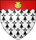 |
The arms of Mortrée are blazoned : Ermine, on a chief indented gules an escallop Or.
|
See also[]
- Communes of the Orne department
References[]
- ^ "Répertoire national des élus: les maires". data.gouv.fr, Plateforme ouverte des données publiques françaises (in French). 2 December 2020.
- ^ "Populations légales 2018". INSEE. 28 December 2020.
- ^ Arrêté préfectoral 28 September 2018, modified 12 November 2018 (in French)
| Wikimedia Commons has media related to Mortrée (commune déléguée). |
| show Communes of the Orne department |
|---|
This Orne geographical article is a stub. You can help Wikipedia by . |
Categories:
- Communes of Orne
- Orne geography stubs