La Lande-Saint-Siméon
La Lande-Saint-Siméon | |
|---|---|
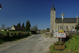 The church in La Lande-Saint-Siméon | |
show Location of La Lande-Saint-Siméon | |
 La Lande-Saint-Siméon | |
| Coordinates: 48°49′23″N 0°26′05″W / 48.8231°N 0.4347°WCoordinates: 48°49′23″N 0°26′05″W / 48.8231°N 0.4347°W | |
| Country | France |
| Region | Normandy |
| Department | Orne |
| Arrondissement | Argentan |
| Canton | Athis-Val de Rouvre |
| Intercommunality | Flers Agglo |
| Government | |
| • Mayor (2008–2014) | Jean Pierre |
| Area 1 | 5.33 km2 (2.06 sq mi) |
| Population (Jan. 2018)[1] | 155 |
| • Density | 29/km2 (75/sq mi) |
| Time zone | UTC+01:00 (CET) |
| • Summer (DST) | UTC+02:00 (CEST) |
| INSEE/Postal code | 61219 /61100 |
| Elevation | 104–227 m (341–745 ft) (avg. 120 m or 390 ft) |
| 1 French Land Register data, which excludes lakes, ponds, glaciers > 1 km2 (0.386 sq mi or 247 acres) and river estuaries. | |


La Lande-Saint-Siméon is a commune in the Orne department in north-western France.
See also[]
- Communes of the Orne department
References[]
- ^ "Populations légales 2018". INSEE. 28 December 2020.
| Wikimedia Commons has media related to La Lande-Saint-Siméon. |
| show Communes of the Orne department |
|---|
This Orne geographical article is a stub. You can help Wikipedia by . |
Categories:
- Communes of Orne
- Orne geography stubs