Lonlay-l'Abbaye
Lonlay-l'Abbaye | |
|---|---|
 Abbey | |
show Location of Lonlay-l'Abbaye | |
 Lonlay-l'Abbaye | |
| Coordinates: 48°38′50″N 0°42′31″W / 48.6472°N 0.7086°WCoordinates: 48°38′50″N 0°42′31″W / 48.6472°N 0.7086°W | |
| Country | France |
| Region | Normandy |
| Department | Orne |
| Arrondissement | Argentan |
| Canton | Domfront en Poiraie |
| Government | |
| • Mayor (2020–2026) | Christian Derouet[1] |
| Area 1 | 53.41 km2 (20.62 sq mi) |
| Population (Jan. 2018)[2] | 1,121 |
| • Density | 21/km2 (54/sq mi) |
| Demonym(s) | Lonléens |
| Time zone | UTC+01:00 (CET) |
| • Summer (DST) | UTC+02:00 (CEST) |
| INSEE/Postal code | 61232 /61700 |
| Elevation | 126–321 m (413–1,053 ft) (avg. 145 m or 476 ft) |
| 1 French Land Register data, which excludes lakes, ponds, glaciers > 1 km2 (0.386 sq mi or 247 acres) and river estuaries. | |


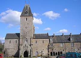
Lonlay-l'Abbaye (French pronunciation: [lɔ̃lɛ labei] (![]() listen)) is a commune in the Orne department in north-western France, situated midway between the towns of Domfront and Flers. It has a beautiful abbey and town square and is surrounded by walks and scenery, including the local viewpoint Fosse Arthur.
listen)) is a commune in the Orne department in north-western France, situated midway between the towns of Domfront and Flers. It has a beautiful abbey and town square and is surrounded by walks and scenery, including the local viewpoint Fosse Arthur.
Heraldry[]
 |
The arms of Lonlay-L'Abbaye are blazoned : Sable, a wolf courant argent.
|
See also[]
- Communes of the Orne department
- Parc naturel régional Normandie-Maine
References[]
- ^ "Répertoire national des élus: les maires". data.gouv.fr, Plateforme ouverte des données publiques françaises (in French). 2 December 2020.
- ^ "Populations légales 2018". INSEE. 28 December 2020.
| Wikimedia Commons has media related to Lonlay-l'Abbaye. |
| show Communes of the Orne department |
|---|
| show Authority control |
|---|
This Orne geographical article is a stub. You can help Wikipedia by . |
Categories:
- Communes of Orne
- Orne geography stubs