Montpinchon
Montpinchon | |
|---|---|
 Montpinchon church | |
show Location of Montpinchon | |
 Montpinchon | |
| Coordinates: 49°01′23″N 1°18′32″W / 49.0231°N 1.3089°WCoordinates: 49°01′23″N 1°18′32″W / 49.0231°N 1.3089°W | |
| Country | France |
| Region | Normandy |
| Department | Manche |
| Arrondissement | Coutances |
| Canton | Quettreville-sur-Sienne |
| Intercommunality | Coutances Mer et Bocage |
| Government | |
| • Mayor (2020–2026) | Valerie Grieu-Leconte[1] |
| Area 1 | 16.94 km2 (6.54 sq mi) |
| Population (Jan. 2018)[2] | 524 |
| • Density | 31/km2 (80/sq mi) |
| Time zone | UTC+01:00 (CET) |
| • Summer (DST) | UTC+02:00 (CEST) |
| INSEE/Postal code | 50350 /50210 |
| Elevation | 37–148 m (121–486 ft) (avg. 142 m or 466 ft) |
| 1 French Land Register data, which excludes lakes, ponds, glaciers > 1 km2 (0.386 sq mi or 247 acres) and river estuaries. | |


Montpinchon is a commune in the Manche department in Normandy in north-western France.
Heraldry[]
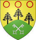 |
The arms of Montpinchon are blazoned : Or, on a mount vert 2 keys in saltire argent, issuant from the mount 3 pine trees sable, and in chief in fess 3 annulets gules. rebus mount+pine ; the 3 annulets are a reference to the arms of the Caillebot de La Salle family, former lords of Montpinchon and Cerisy
|
See also[]
- Communes of the Manche department
References[]
- ^ "Répertoire national des élus: les maires". data.gouv.fr, Plateforme ouverte des données publiques françaises (in French). 2 December 2020.
- ^ "Populations légales 2018". INSEE. 28 December 2020.
| Wikimedia Commons has media related to Montpinchon. |
| show Communes of Manche |
|---|
| show Authority control |
|---|
This Manche geographical article is a stub. You can help Wikipedia by . |
Categories:
- Communes of Manche
- Manche geography stubs