Saint-Marcouf, Manche
Saint-Marcouf | |
|---|---|
 The church of Saint-Marcouf | |
show Location of Saint-Marcouf | |
 Saint-Marcouf | |
| Coordinates: 49°28′26″N 1°17′22″W / 49.4739°N 1.2894°WCoordinates: 49°28′26″N 1°17′22″W / 49.4739°N 1.2894°W | |
| Country | France |
| Region | Normandy |
| Department | Manche |
| Arrondissement | Cherbourg |
| Canton | Valognes |
| Intercommunality | CA Cotentin |
| Government | |
| • Mayor (2020–2026) | Jean-Claude Legoupil[1] |
| Area 1 | 13.38 km2 (5.17 sq mi) |
| Population (Jan. 2018)[2] | 342 |
| • Density | 26/km2 (66/sq mi) |
| Time zone | UTC+01:00 (CET) |
| • Summer (DST) | UTC+02:00 (CEST) |
| INSEE/Postal code | 50507 /50310 |
| 1 French Land Register data, which excludes lakes, ponds, glaciers > 1 km2 (0.386 sq mi or 247 acres) and river estuaries. | |


Saint-Marcouf (French pronunciation: [sɛ̃ maʁkuf] (![]() listen)) is a commune in the Manche department in Normandy in north-western France.
listen)) is a commune in the Manche department in Normandy in north-western France.
Second World War[]
During the Second World War, a German coastal battery near the village was bombed but fired on Allied forces landing on Utah Beach on D-Day and again on the 8th of June before being silenced by US battleships.
Heraldry[]
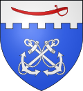 |
The arms of Saint-Marcouf are blazoned : Azure, two anchors in saltire, hawsers interlaced, and on a chief embattled argent a boarding cutlass point to dexter gules.
|
See also[]
- Communes of the Manche department
References[]
- ^ "Répertoire national des élus: les maires". data.gouv.fr, Plateforme ouverte des données publiques françaises (in French). 2 December 2020.
- ^ "Populations légales 2018". INSEE. 28 December 2020.
| Wikimedia Commons has media related to Saint-Marcouf, Manche. |
| show Communes of Manche |
|---|
This Manche geographical article is a stub. You can help Wikipedia by . |
Categories:
- Communes of Manche
- Manche geography stubs