Saint-Senier-sous-Avranches
Saint-Senier-sous-Avranches | |
|---|---|
 View of the village | |
show Location of Saint-Senier-sous-Avranches | |
 Saint-Senier-sous-Avranches | |
| Coordinates: 48°41′07″N 1°20′24″W / 48.6853°N 1.34°WCoordinates: 48°41′07″N 1°20′24″W / 48.6853°N 1.34°W | |
| Country | France |
| Region | Normandy |
| Department | Manche |
| Arrondissement | Avranches |
| Canton | Isigny-le-Buat |
| Government | |
| • Mayor (2020–2026) | Alain Fontaine |
| Area 1 | 8.62 km2 (3.33 sq mi) |
| Population (Jan. 2018)[1] | 1,433 |
| • Density | 170/km2 (430/sq mi) |
| Time zone | UTC+01:00 (CET) |
| • Summer (DST) | UTC+02:00 (CEST) |
| INSEE/Postal code | 50554 /50300 |
| Elevation | 7–126 m (23–413 ft) (avg. 80 m or 260 ft) |
| 1 French Land Register data, which excludes lakes, ponds, glaciers > 1 km2 (0.386 sq mi or 247 acres) and river estuaries. | |


Saint-Senier-sous-Avranches (French pronunciation: [sɛ̃ sənje su.z‿avʁɑ̃ʃ], literally Saint Senier under Avranches) is a commune in the Manche department in Normandy in north-western France.
Heraldry[]
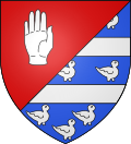 |
The arms of Saint-Senier-sous-Avranches are blazoned : Per bend sinister 1: Gules, a hand appaumy argent 2: Azure, 2 fesses and 9 martlets countourny argent (dimidiated).
|
See also[]
- Communes of the Manche department
References[]
- ^ "Populations légales 2018". INSEE. 28 December 2020.
| Wikimedia Commons has media related to Saint-Senier-sous-Avranches. |
| show Communes of Manche |
|---|
This Manche geographical article is a stub. You can help Wikipedia by . |
Categories:
- Communes of Manche
- Manche geography stubs