Auvers, Manche
Auvers | |
|---|---|
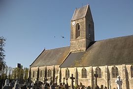 Saint-Étienne church and the château | |
show Location of Auvers | |
 Auvers | |
| Coordinates: 49°17′59″N 1°19′07″W / 49.2997°N 1.3186°WCoordinates: 49°17′59″N 1°19′07″W / 49.2997°N 1.3186°W | |
| Country | France |
| Region | Normandy |
| Department | Manche |
| Arrondissement | Saint-Lô |
| Canton | Carentan-les-Marais |
| Intercommunality | |
| Government | |
| • Mayor (2014-2020) | Guy Foucher |
| Area 1 | 18.76 km2 (7.24 sq mi) |
| Population (Jan. 2018)[1] | 676 |
| • Density | 36/km2 (93/sq mi) |
| Time zone | UTC+01:00 (CET) |
| • Summer (DST) | UTC+02:00 (CEST) |
| INSEE/Postal code | 50023 /50500 |
| Elevation | 0–26 m (0–85 ft) (avg. 5 m or 16 ft) |
| 1 French Land Register data, which excludes lakes, ponds, glaciers > 1 km2 (0.386 sq mi or 247 acres) and river estuaries. | |


Auvers is a commune in the Manche department in the Normandy region in northwestern France.
Population[]
|
|
See also[]
- Communes of the Manche department
References[]
- ^ "Populations légales 2018". INSEE. 28 December 2020.
| Wikimedia Commons has media related to Auvers (Manche). |
| show Communes of Manche |
|---|
This Manche geographical article is a stub. You can help Wikipedia by . |
Categories:
- Communes of Manche
- Manche geography stubs