Beaucoudray
Beaucoudray | |
|---|---|
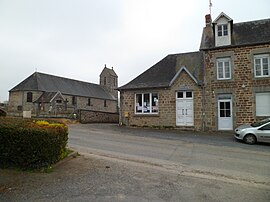 The town hall and the church of Saint-Laurent | |
show Location of Beaucoudray | |
 Beaucoudray | |
| Coordinates: 48°57′33″N 1°08′27″W / 48.9592°N 1.1408°WCoordinates: 48°57′33″N 1°08′27″W / 48.9592°N 1.1408°W | |
| Country | France |
| Region | Normandy |
| Department | Manche |
| Arrondissement | Saint-Lô |
| Canton | Condé-sur-Vire |
| Government | |
| • Mayor (2020–2026) | Michel de Beaucoudrey[1] |
| Area 1 | 4.70 km2 (1.81 sq mi) |
| Population (Jan. 2018)[2] | 131 |
| • Density | 28/km2 (72/sq mi) |
| Time zone | UTC+01:00 (CET) |
| • Summer (DST) | UTC+02:00 (CEST) |
| INSEE/Postal code | 50039 /50420 |
| Elevation | 84–204 m (276–669 ft) (avg. 170 m or 560 ft) |
| 1 French Land Register data, which excludes lakes, ponds, glaciers > 1 km2 (0.386 sq mi or 247 acres) and river estuaries. | |


Beaucoudray is a commune in the Manche department in the Normandy region in northwestern France.
Population[]
|
|
See also[]
- Communes of the Manche department
References[]
- ^ "Répertoire national des élus: les maires". data.gouv.fr, Plateforme ouverte des données publiques françaises (in French). 2 December 2020.
- ^ "Populations légales 2018". INSEE. 28 December 2020.
| Wikimedia Commons has media related to Beaucoudray. |
| show Communes of Manche |
|---|
This Manche geographical article is a stub. You can help Wikipedia by . |
Categories:
- Communes of Manche
- Manche geography stubs