Emberménil
show This article may be expanded with text translated from the corresponding article in French. (January 2021) Click [show] for important translation instructions. |
Emberménil | |
|---|---|
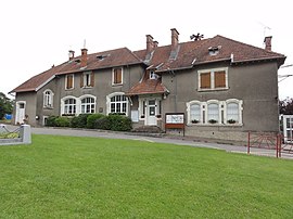 The town hall in Emberménil | |
 Coat of arms | |
show Location of Emberménil | |
 Emberménil | |
| Coordinates: 48°37′47″N 6°41′47″E / 48.6297°N 6.6964°ECoordinates: 48°37′47″N 6°41′47″E / 48.6297°N 6.6964°E | |
| Country | France |
| Region | Grand Est |
| Department | Meurthe-et-Moselle |
| Arrondissement | Lunéville |
| Canton | Baccarat |
| Government | |
| • Mayor (2008–2014) | Jean-Paul Martin |
| Area 1 | 14.39 km2 (5.56 sq mi) |
| Population (Jan. 2018)[1] | 258 |
| • Density | 18/km2 (46/sq mi) |
| Time zone | UTC+01:00 (CET) |
| • Summer (DST) | UTC+02:00 (CEST) |
| INSEE/Postal code | 54177 /54370 |
| Elevation | 234–313 m (768–1,027 ft) (avg. 250 m or 820 ft) |
| 1 French Land Register data, which excludes lakes, ponds, glaciers > 1 km2 (0.386 sq mi or 247 acres) and river estuaries. | |


Emberménil (French pronunciation: [ɑ̃bɛʁmenil]) is a commune in the Meurthe-et-Moselle department in north-eastern France.
See also[]
References[]
- ^ "Populations légales 2018". INSEE. 28 December 2020.
| Wikimedia Commons has media related to Emberménil. |
This Meurthe-et-Moselle geographical article is a stub. You can help Wikipedia by . |
Categories:
- Communes of Meurthe-et-Moselle
- Meurthe-et-Moselle geography stubs