Val-et-Châtillon
Val-et-Châtillon | |
|---|---|
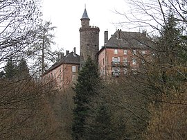 The chateau in Val-et-Châtillon | |
 Coat of arms | |
show Location of Val-et-Châtillon | |
 Val-et-Châtillon | |
| Coordinates: 48°33′34″N 6°58′01″E / 48.5594°N 6.9669°ECoordinates: 48°33′34″N 6°58′01″E / 48.5594°N 6.9669°E | |
| Country | France |
| Region | Grand Est |
| Department | Meurthe-et-Moselle |
| Arrondissement | Lunéville |
| Canton | Baccarat |
| Intercommunality | CC de Vezouze en Piémont |
| Government | |
| • Mayor (2008–2014) | Josiane Tallotte |
| Area 1 | 18.57 km2 (7.17 sq mi) |
| Population (Jan. 2018)[1] | 588 |
| • Density | 32/km2 (82/sq mi) |
| Time zone | UTC+01:00 (CET) |
| • Summer (DST) | UTC+02:00 (CEST) |
| INSEE/Postal code | 54540 /54480 |
| Elevation | 295–670 m (968–2,198 ft) (avg. 310 m or 1,020 ft) |
| 1 French Land Register data, which excludes lakes, ponds, glaciers > 1 km2 (0.386 sq mi or 247 acres) and river estuaries. | |


Val-et-Châtillon is a commune in the Meurthe-et-Moselle department in north-eastern France.
See also[]
References[]
- ^ "Populations légales 2018". INSEE. 28 December 2020.
| Wikimedia Commons has media related to Val-et-Châtillon. |
This Meurthe-et-Moselle geographical article is a stub. You can help Wikipedia by . |
Categories:
- Communes of Meurthe-et-Moselle
- Meurthe-et-Moselle geography stubs