Lalœuf
Laloeuf | |
|---|---|
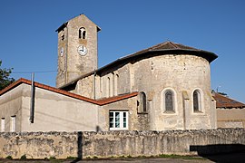 The church of Saint-Rémy of Puxe in Lalœuf | |
 Coat of arms | |
show Location of Laloeuf | |
 Laloeuf | |
| Coordinates: 48°27′37″N 6°00′58″E / 48.4603°N 6.0161°ECoordinates: 48°27′37″N 6°00′58″E / 48.4603°N 6.0161°E | |
| Country | France |
| Region | Grand Est |
| Department | Meurthe-et-Moselle |
| Arrondissement | Nancy |
| Canton | Meine au Saintois |
| Intercommunality | CC Pays du Saintois |
| Government | |
| • Mayor (2020–2026) | Olivier Bergé[1] |
| Area 1 | 10.68 km2 (4.12 sq mi) |
| Population (Jan. 2018)[2] | 290 |
| • Density | 27/km2 (70/sq mi) |
| Time zone | UTC+01:00 (CET) |
| • Summer (DST) | UTC+02:00 (CEST) |
| INSEE/Postal code | 54291 /54115 |
| Elevation | 279–405 m (915–1,329 ft) (avg. 300 m or 980 ft) |
| 1 French Land Register data, which excludes lakes, ponds, glaciers > 1 km2 (0.386 sq mi or 247 acres) and river estuaries. | |


Lalœuf (French pronunciation: [lalœf]) is a commune in the Meurthe-et-Moselle department in north-eastern France.
See also[]
References[]
- ^ "Répertoire national des élus: les maires". data.gouv.fr, Plateforme ouverte des données publiques françaises (in French). 2 December 2020.
- ^ "Populations légales 2018". INSEE. 28 December 2020.
External links[]
| Wikimedia Commons has media related to Lalœuf. |
This Meurthe-et-Moselle geographical article is a stub. You can help Wikipedia by . |
Categories:
- Communes of Meurthe-et-Moselle
- Meurthe-et-Moselle geography stubs