Tonnoy
Tonnoy | |
|---|---|
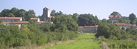 A general view of Tonnoy | |
 Coat of arms | |
show Location of Tonnoy | |
 Tonnoy | |
| Coordinates: 48°33′07″N 6°15′02″E / 48.5519°N 6.2506°ECoordinates: 48°33′07″N 6°15′02″E / 48.5519°N 6.2506°E | |
| Country | France |
| Region | Grand Est |
| Department | Meurthe-et-Moselle |
| Arrondissement | Nancy |
| Canton | Lunéville-2 |
| Intercommunality | Pays du Sel et du Vermois |
| Government | |
| • Mayor (2020–2026) | Yvon Valette |
| Area 1 | 12.35 km2 (4.77 sq mi) |
| Population (Jan. 2018)[1] | 685 |
| • Density | 55/km2 (140/sq mi) |
| Time zone | UTC+01:00 (CET) |
| • Summer (DST) | UTC+02:00 (CEST) |
| INSEE/Postal code | 54527 /54210 |
| Elevation | 229–369 m (751–1,211 ft) (avg. 260 m or 850 ft) |
| Website | www.mairie-tonnoy.fr |
| 1 French Land Register data, which excludes lakes, ponds, glaciers > 1 km2 (0.386 sq mi or 247 acres) and river estuaries. | |


Tonnoy (French pronunciation: [tɔnwa]) is a commune in the Meurthe-et-Moselle department in north-eastern France.
See also[]
References[]
- ^ "Populations légales 2018". INSEE. 28 December 2020.
| Wikimedia Commons has media related to Tonnoy. |
This Meurthe-et-Moselle geographical article is a stub. You can help Wikipedia by . |
Categories:
- Communes of Meurthe-et-Moselle
- Meurthe-et-Moselle geography stubs