Fleury, Manche
Fleury | |
|---|---|
 Town hall | |
show Location of Fleury | |
 Fleury | |
| Coordinates: 48°50′55″N 1°16′28″W / 48.8486°N 1.2744°WCoordinates: 48°50′55″N 1°16′28″W / 48.8486°N 1.2744°W | |
| Country | France |
| Region | Normandy |
| Department | Manche |
| Arrondissement | Saint-Lô |
| Canton | Villedieu-les-Poêles-Rouffigny |
| Intercommunality | Villedieu Intercom |
| Government | |
| • Mayor (2020–2026) | Daniel Vesval[1] |
| Area 1 | 12.60 km2 (4.86 sq mi) |
| Population (Jan. 2018)[2] | 1,039 |
| • Density | 82/km2 (210/sq mi) |
| Demonym(s) | Fleurions |
| Time zone | UTC+01:00 (CET) |
| • Summer (DST) | UTC+02:00 (CEST) |
| INSEE/Postal code | 50185 /50800 |
| Elevation | 109–201 m (358–659 ft) (avg. 150 m or 490 ft) |
| 1 French Land Register data, which excludes lakes, ponds, glaciers > 1 km2 (0.386 sq mi or 247 acres) and river estuaries. | |


Fleury (French pronunciation: [flœʁi] (![]() listen)) is a commune in the Manche department in north-western France.
listen)) is a commune in the Manche department in north-western France.
Notable residents[]
Michael Vartan
Gallery[]
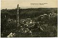
Ruins of Fleury after World War I

See also[]
- Communes of the Manche department
References[]
- ^ "Répertoire national des élus: les maires". data.gouv.fr, Plateforme ouverte des données publiques françaises (in French). 2 December 2020.
- ^ "Populations légales 2018". INSEE. 28 December 2020.
| Wikimedia Commons has media related to Fleury (Manche). |
| show Communes of Manche |
|---|
This Manche geographical article is a stub. You can help Wikipedia by . |
Categories:
- Communes of Manche
- Manche geography stubs