La Flotte
show This article may be expanded with text translated from the corresponding article in French. (December 2008) Click [show] for important translation instructions. |
La Flotte | |
|---|---|
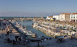 The harbour in La Flotte | |
 Coat of arms | |
show Location of La Flotte | |
 La Flotte | |
| Coordinates: 46°11′16″N 1°19′28″W / 46.1878°N 1.3244°WCoordinates: 46°11′16″N 1°19′28″W / 46.1878°N 1.3244°W | |
| Country | France |
| Region | Nouvelle-Aquitaine |
| Department | Charente-Maritime |
| Arrondissement | La Rochelle |
| Canton | Île de Ré |
| Intercommunality | Île de Ré |
| Government | |
| • Mayor (2008–2014) | Léon Gendre |
| Area 1 | 12.32 km2 (4.76 sq mi) |
| Population (Jan. 2018)[1] | 2,759 |
| • Density | 220/km2 (580/sq mi) |
| Time zone | UTC+01:00 (CET) |
| • Summer (DST) | UTC+02:00 (CEST) |
| INSEE/Postal code | 17161 /17630 |
| Elevation | 0–17 m (0–56 ft) (avg. 8 m or 26 ft) |
| 1 French Land Register data, which excludes lakes, ponds, glaciers > 1 km2 (0.386 sq mi or 247 acres) and river estuaries. | |


Entrance to the harbour
La Flotte is a commune in the Charente-Maritime department in southwestern France. It is situated on the Île de Ré.
Population[]
| Year | Pop. | ±% |
|---|---|---|
| 1962 | 1,578 | — |
| 1968 | 1,681 | +6.5% |
| 1975 | 1,737 | +3.3% |
| 1982 | 1,878 | +8.1% |
| 1990 | 2,452 | +30.6% |
| 1999 | 2,737 | +11.6% |
| 2008 | 2,946 | +7.6% |
See also[]
References[]
- ^ "Populations légales 2018". INSEE. 28 December 2020.
- ^ "POPULATION LA FLOTTE : statistics of La Flotte 17630". www.map-france.com. Retrieved 2020-06-29.
| Wikimedia Commons has media related to La Flotte. |
| show Villages in the association Les Plus Beaux Villages de France |
|---|
| show Authority control |
|---|
This Charente-Maritime geographical article is a stub. You can help Wikipedia by . |
Categories:
- Communes of Charente-Maritime
- Plus Beaux Villages de France
- Île de Ré
- Charente-Maritime geography stubs