Otoyol
| Otoyol | |
|---|---|
 Route markers for three Turkish Motorways | |
 Otoyol network in Turkey. Motorways in use, under construction and projected. | |
| System information | |
| Maintained by Karayolları Genel Müdürlüğü | |
| Formed | 1968[1] |
| Highway names | |
| Otoyols: | Otoyol XX (O-XX) |
| System links | |
| |
The Otoyol (Plural: Otoyollar) is the national network of controlled-access highways in Turkey. The network spans 3,523 kilometres (2,189 mi) as of 2020-end[3] and was first opened in 1973. Another term for the system is Otoban, which is a popular but unofficial term transcribed from the German word autobahn. The term Otoyol translates to motorway while the literal meaning is auto-route.
The Otoyol system previously consisted of three separate networks; the Edirne-Istanbul-Ankara corridor, the Aegean network centered around İzmir, and the Southeastern network centered around Adana. With the completion of the O-5 in 2019 and the extension of the O-21 in 2020, these three networks have since been connected. The network is expected to expand to 4,773 kilometres (2,966 mi) by 2023 and to 9,312 kilometres (5,786 mi) by 2035.[4] The minimum speed limit on the Turkish otoyols is 40 km/h (25 mph) while the maximum speed is 120 km/h (75 mph).[5]
History[]
The construction of a national road system was prioritized in 1948, where the construction of new roads were greatly accelerated. This led to a rise in automobile usage in Turkey. By the 1960s, traffic problems were becoming prevalent in large cities and capacity on intercity roads needed to be upgraded. Plans to build new expressways were put into action in 1968, when construction of the Istanbul Inner Beltway was started.[6] The Beltway, known as the O-1, was opened together with the Bosporus Bridge in 1973 with great fanfare. This became the first motorway to be built in Turkey. The Istanbul Beltway was then to be a part of a large expressway spanning from Edirne, in East Thrace, to İskenderun, on the eastern shore of the Mediterranean Sea. Construction of this expressway first started in 1973 on a 14 km (8.7 mi) section between Pozantı and Akçatekir, on what would become the O-21. In 1975 construction of a 40 km (25 mi) section of the motorway from Gebze to Izmit was started. Due to financial problems during the following years, construction of the two otoyols were greatly slowed down. It wasn't until 1984 that these two motorways were opened to traffic.[1]
Turgut Özal became Prime Minister in 1983 and brought forth a policy of constructing new otoyols in Turkey. In 1985, construction of an intercontinental motorway spanning 772 km (480 mi) from Edirne to Ankara was started. This motorway project would serve as an outer beltway round Istanbul and also included the construction of a second bridge over the Bosporus, the Fatih Sultan Mehmet Bridge. The first section of the motorway, the 20 km (12 mi) long Edirne Beltway, was opened in 1987, followed by the opening of the Outer Beltway in Istanbul, from Levent to Kozyatağı, together with the FSM Bridge on 3 July 1988. The motorway was opened in sections in the following years until being completed in 1994. 2 decades later O-7 or Third Beltway opened in 2017.
In 1988 the construction of three new motorways in Izmir were started. O-32 opened in 1992 and it became first motorway in Agean Region. O-30 was built 1 year after. And a year after O-31 was opened, running between İzmir and Aydın. Finally in 2008, O-30 was completed. First section of O-5 was opened between Kemalpaşa and Bornova. Finally O-33 was opened in February 2020. (Which is the continuous part of O-30)
List of Otoyol routes[]
| Number | Length (km) | Length (mi) | Northern or western terminus | Southern or eastern terminus | Built | Notes |
|---|---|---|---|---|---|---|
| 20.5 | 12.7 | Bağdat Ave. in Kadıköy, Istanbul | 1970 till 1973 | Istanbul Inner Beltway including the Bosphorus Bridge | ||
| 36.9 | 22.9 | 1986 till 1988 | Istanbul Outer Beltway including the Fatih Sultan Mehmet Bridge | |||
| 246.9 | 153.4 | 1987 | İstanbul-Edirne (Bulgaria-Greece-Turkey border) Motorway | |||
| 372 | 231.2 | 1984 till 2007 | İstanbul-Ankara Motorway, including the Mount Bolu Tunnel | |||
| 409.4 | 254.4 | 2016 till 2019 | İstanbul-Bursa-İzmir Motorway, including the Osman Gazi Bridge | |||
| 275.2 | 171.1 | 2016 till 2020 | Contains the northernmost beltway of İstanbul, including the Yavuz Sultan Selim Bridge | |||
| 110 | 68.4 | Road forms complete ring around Ankara | Road forms complete ring around Ankara | 1987 | Ankara Beltway | |
| 399.5 | 248.3 | 1984 till 2020 | Ankara-Çukurova Motorway | |||
| 32 | 19.9 | 1992 | ||||
| 34.1 | 21.2 | 2006 | ||||
| 60.4 | 37.5 | 1993 till 2006 | İzmir Beltway | |||
| 127.8 | 79.4 | 1996 till 2004 | İzmir-Aydın Motorway | |||
| 77.7 | 48.3 | 1065 Sk. in Çeşme | Mustafa Kemal Sahil Blv. in Balçova, Izmir | 1992 till 1996 | İzmir-Çeşme Motorway | |
| 76 | 47 | Port of Çandarlı near Çandarlı | 2019 | İzmir-Çandarlı Motorway | ||
| 99.2 | 61.6 | 1992 | Adana-Mersin Motorway | |||
| 365 | 226.8 | 1992 | Adana-Gaziantep-Şanlıurfa Motorway | |||
| 150 | 93.2 | 1993 | ||||
| 35 | 21.7 | 2013 | Gaziantep Beltway |
Projects[]
Under Construction[]
| Number | Length (km) | Length (mi) | Northern or western terminus | Southern or eastern terminus | Opens | Notes |
|---|---|---|---|---|---|---|
| 101 | 62.8 | 2022 | The section including the Çanakkale 1915 Bridge will be opened in March 2022 | |||
| 165 | 102.5 | 2023 | ||||
| 45 | 28 | 2023 |
Tender Phase[]
| Number | Length (km) | Length (mi) | Northern or western terminus | Southern or eastern terminus | Tender Date | Notes |
|---|---|---|---|---|---|---|
| 98 | 60.9 | 23.09.2021 | ||||
| 114 | 70.8 | N/A | Part of Kınalı-Balıkesir Motorway. | |||
| 119 | 73.9 | N/A | Part of Ankara-Samsun Motorway. Delice-Samsun section still in planning phase. | |||
| 130 | 80.8 | N/A | Part of Izmir–Ankara Motorway. İzmir-Sivrihisar section still in planning phase. | |||
| 137 | 85.2 | N/A | Part of . Ilgaz-Merzifon-Koyulhisar-Pülümür-Horasan-Gürbulak sections still in planning phase. | |||
| 155 | 96.3 | N/A | Part of . Afyonkarahisar-Burdur-Antalya section still in planning phase. | |||
| 31.3 | 19.5 | N/A | Dörtyol-Hassa Motorway |
Planning Phase[]
| Number | Length (km) | Length (mi) | Northern or western terminus | Southern or eastern terminus | Tender Date | Notes |
|---|---|---|---|---|---|---|
| 12 | 7.46 | N/A | - Gulf of İzmir Passage Project between Çiğli (Sasalı) and Balçova (İnciraltı); including one undersea tunnel and one bridge | |||
| 41 | 25.5 | N/A | İzmir 2. peripheral motorway | |||
| 155 | 96.3 | N/A | Denizli-Burdur section of Aydın-Denizli-Burdur Motorway | |||
| 137 | 85.1 | N/A | Lapseki-Balıkesir section of Kınalı-Balıkesir Motorway | |||
| 350 | 217.5 | N/A | ||||
| 408 | 253.5 | N/A | Sivrihisar-İzmir section of Ankara-İzmir Motorway | |||
| 231 | 143.5 | N/A | Sivrihisar-Bursa Motorway | |||
| 454 | 282.1 | N/A | Şanlıurfa-Mardin-Habur Motorway (including link to Diyarbakır) (border crossing) | |||
| 303 | 188.3 | N/A | Delice-Samsun section of Ankara-Samsun Motorway | |||
| 144 | 89.5 | N/A | Bafra-Samsun-Ünye Motorway | |||
| 183 | 113.7 | N/A | ||||
| 919 | 571 | N/A | (border crossing) | |||
| 91 | 56.6 | N/A | ||||
| 440 | 273.4 | N/A | Afyonkarahisar-Konya-Ereğli-Niğde (Ulukışla) Motorway | |||
| 105 | 65.3 | N/A | Bozüyük-Afyonkarahisar Motorway | |||
| 200 | 124.3 | N/A | Alanya-Silifke Motorway | |||
| 105 | 65.3 | N/A | Düzce-Zonguldak Motorway | |||
| 500 | 310.7 | N/A | Delice-Sivas-Refahiye Motorway | |||
| 600 | 372.8 | N/A | Nevşehir-Kayseri-Malatya-Diyarbakır Motorway | |||
| 220 | 136.7 | N/A | Sivas-Malatya Motorway | |||
| 50 | 31.1 | N/A | Şanlıurfa-Akçakale Motorway (border crossing) | |||
| 475 | 295.2 | N/A | Diyarbakır-Gürbulak Motorway (border crossing) | |||
| 540 | 335.6 | N/A | Trabzon-Refahiye-Malatya-Kahramanmaraş Motorway | |||
| 250 | 155.4 | N/A | Pasinler-Türkgözü Motorway (border crossing) | |||
| 460 | 285.8 | N/A | Rize-Erzurum-Diyarbakır Motorway | |||
| 78 | 48.5 | N/A | İskenderun-Cilvegözü Motorway (border crossing) | |||
| 80 | 49.7 | N/A | Çandarlı-Bergama-Savaştepe Motorway | |||
| 90 | 55.9 | N/A | Aydın-Muğla Motorway | |||
| 75 | 46.6 | N/A | Malkara-İpsala Motorway (border crossing) | |||
| 130 | 80.8 | N/A | Havsa-Gelibolu Motorway | |||
| 180 | 111.9 | N/A | Lapseki-Karacabey Motorway |
Toll[]

Most motorways are toll roads. The toll is based on the distance traveled. On most sections, the toll can be paid only with RFID-based HGS and OGS. Cash and KGS card payment methods have mostly been abolished in recent years. Only the newly opened Otoyol 5, and Otoyol 7 have sections where it is possible to pay by cash or with credit card. Apart from motorways, the other state roads in Turkey are free of charge.
The revenue from tolls in 2001 were still about $203 million, rising by 2012 to approximately $542 million. In 2012, the Bosphorus bridges saw 150 million vehicles pass and the other toll roads saw over 210 million vehicles.[7] In 2015, both bridges were used by 141 million vehicles while the other toll motorways were used by 271 million vehicles, generating a total revenue of $391 million (both bridges and motorways combined).[8]
Standards[]
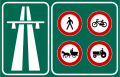
Mainly because the country already has a wide network of double carriageways, the standards for motorways in comparison are very high. Most sections of otoyols have 3 lanes in each direction, aside from the O-4 around Izmit, a small stretch of the O-3 between Silivri and Esenyurt, and the section of O-32 between Alaçatı and Çeşme, which only have two lanes in each direction. Also the O-2, the O-7 and the O-20 all have four lanes in each direction along the entire route. The lanes are each 3.75 meters wide. Most exits have a connection road, which helps avoiding wrong-way driving and illegal access to the road (bikes, tractors and horses are not allowed on otoyols).
The minimum speed is 40 km/h (25 mph) and the maximum allowed speed is 120 km/h (75 mph), although speeding is not punished under 132 km/h (82 mph). However, on sections of the O-1 through central Istanbul the speed limit is 70 km/h (45 mph). In most tunnels the speed limit is 90 km/h (55 mph).
Alongside otoyols, there are resting areas, which are standardized as A, B, C and D type service areas. The D type is mainly a parking area. The C type has a fuel station added. The B type has a fuel station and a vehicle service station added. The A type additionally has a motel (in urban ones, this motel is traded for a large shopping mall).
Dangerous stretches such as tunnels or bridges where there is often fog, exits, interchanges and service areas are illuminated.
Since gradients are expected to be very low and turning radii are expected to be very high, otoyols have many bridges and tunnels which makes them very expensive to construct.
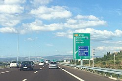
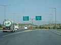
Otoyol signs in Turkey are green and uses the Highway Gothic typeface.
Statistics[]

Length[]
- Longest otoyol: 432 km (268 mi), O-21 between Ankara and Tarsus.
- Shortest otoyol: 20.5 km (12.7 mi), O-1 in Istanbul[9]
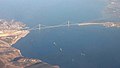
- Longest bridge: Osman Gazi Bridge, carries the O-5 over the Gulf of İzmit.
- Longest tunnel: Tunnel 4, on the O-7.
Provinces[]
- Number of Provinces with an otoyol route(s): 27 provinces (Adana, Aksaray, Ankara, Aydın, Balıkesir, Bolu, Bursa, Düzce, Edirne, Gaziantep, Hatay, Istanbul, Izmir, Kahramanmaraş, Kırklareli, Kırşehir, Kocaeli, Konya, Manisa, Mersin, Nevşehir, Niğde, Osmaniye, Sakarya, Şanlıurfa, Tekirdağ, Yalova)
- Most otoyols in a province:
- Most provinces served by an otoyol:
- 8 provinces served by the O-21: Ankara, Konya, Aksaray, Kırşehir, Nevşehir, Niğde, Adana, Mersin
- 6 provinces served by the O-4: Istanbul, Kocaeli, Sakarya, Düzce, Bolu, Ankara
- 6 provinces served by the O-5: Kocaeli, Yalova, Bursa, Balıkesir, Manisa, İzmir
- 5 provinces served by the O-52: Adana, Osmaniye, Kahramanmaraş, Gaziantep, Şanlıurfa
Gallery[]

Junction of the O-2 and O-3 in Istanbul

O-1 and the Haliç Bridge, with the Metrobus line in between the two carriageways

The O-4 near Ankara

O-2 near the FSM Bridge

O-31 in Izmir
Junction of O-30 and O-31 near Buca, Izmir

Yavuz Sultan Selim Bridge on the O-7
Osmangazi Bridge on the O-5
Otoyol entrance sign


See also[]
- List of motorway tunnels in Turkey
- Turkish State Highway System
- List of highways in Turkey
- List of controlled-access highway systems
- Transport in Turkey
- Roads in Turkey
References[]
- ^ a b Muhteşem Kaynak - Türkiye'de Otoyollar
- ^ Length of Motorways
- ^ https://www.kgm.gov.tr/SiteCollectionDocuments/KGMdocuments/Istatistikler/OtoyolEnvanterBilgisi/Yillara%C4%B0tibariyleYapimiTamamlanmisOtoyollar.pdf
- ^ Infrastrukturprojekte sollen die türkische Bauwirtschaft ankurbeln Archived 2013-02-10 at archive.today, Germany Trade and Invest, 24. November 2009
- ^ "Hız Sınırları" (in Turkish). KGM. Archived from the original on 11 May 2015. Retrieved 14 April 2014.
- ^ Birol Cetin, Serap Baris, Serap Saroglu - Türkiye’de Karayollarının Gelişimine Tarihsel Bir Bakış, p.173
- ^ "Otoyol ve Köprü Gelirleri (2001-2012)" (PDF) (in Turkish). KGM. Archived from the original (PDF) on 4 March 2016. Retrieved 18 June 2013.
- ^ http://www.kgm.gov.tr/SiteCollectionDocuments/KGMdocuments/Istatistikler/OtoyolMaliBilgileri/OtoyolVeKopruGelirleri%282001-2015%29.pdf Otoyol statistics
- ^ Dairesi, Karayolları Genel Müdürlüğü Bilgi İşlem. "otoyolharitalari". www.kgm.gov.tr (in Turkish). Retrieved 2018-01-31.
| Current |  | |
|---|---|---|
| Former | ||
| Under construction | ||
| Planned | ||
| ||
Motorways in Asia | |
|---|---|
| Sovereign states |
|
| States with limited recognition | |
| Dependencies and other territories | |
| |
- Highways in Turkey
- Lists of roads by country
- Lists of buildings and structures in Turkey
- Turkey transport-related lists