Quetteville
show This article may be expanded with text translated from the corresponding article in French. (December 2008) Click [show] for important translation instructions. |
Quetteville | |
|---|---|
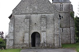 The church in Quetteville | |
show Location of Quetteville | |
 Quetteville | |
| Coordinates: 49°20′15″N 0°18′34″E / 49.3375°N 0.3094°ECoordinates: 49°20′15″N 0°18′34″E / 49.3375°N 0.3094°E | |
| Country | France |
| Region | Normandy |
| Department | Calvados |
| Arrondissement | Lisieux |
| Canton | Honfleur-Deauville |
| Intercommunality | Pays de Honfleur-Beuzeville |
| Government | |
| • Mayor (2020–2026) | Richard Griset |
| Area 1 | 10.32 km2 (3.98 sq mi) |
| Population (Jan. 2018)[1] | 383 |
| • Density | 37/km2 (96/sq mi) |
| Time zone | UTC+01:00 (CET) |
| • Summer (DST) | UTC+02:00 (CEST) |
| INSEE/Postal code | 14528 /14130 |
| Elevation | 30–141 m (98–463 ft) (avg. 85 m or 279 ft) |
| 1 French Land Register data, which excludes lakes, ponds, glaciers > 1 km2 (0.386 sq mi or 247 acres) and river estuaries. | |


Quetteville (French pronunciation: [kɛtvil] (![]() listen)) is a commune in the Calvados department in the Normandy region in northwestern France.
listen)) is a commune in the Calvados department in the Normandy region in northwestern France.
Population[]
| Year | Pop. | ±% |
|---|---|---|
| 1962 | 311 | — |
| 1968 | 303 | −2.6% |
| 1975 | 251 | −17.2% |
| 1982 | 221 | −12.0% |
| 1990 | 263 | +19.0% |
| 1999 | 295 | +12.2% |
| 2008 | 375 | +27.1% |
See also[]
- Communes of the Calvados department
References[]
- ^ "Populations légales 2018". INSEE. 28 December 2020.
| Wikimedia Commons has media related to Quetteville. |
| show Communes of the Calvados department |
|---|
This Calvados geographical article is a stub. You can help Wikipedia by . |
Categories:
- Communes of Calvados (department)
- Calvados (department) geography stubs