Rots
show This article may be expanded with text translated from the corresponding article in French. (December 2008) Click [show] for important translation instructions. |
Rots | |
|---|---|
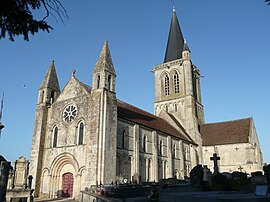 Saint Ouen | |
 Coat of arms | |
show Location of Rots | |
 Rots | |
| Coordinates: 49°12′30″N 0°28′36″W / 49.2083°N 0.4767°WCoordinates: 49°12′30″N 0°28′36″W / 49.2083°N 0.4767°W | |
| Country | France |
| Region | Normandy |
| Department | Calvados |
| Arrondissement | Caen |
| Canton | Bretteville-l'Orgueilleuse |
| Intercommunality | CU Caen la Mer |
| Government | |
| • Mayor (2020–2026) | Michel Bourguignon |
| Area 1 | 23.40 km2 (9.03 sq mi) |
| Population (Jan. 2018)[1] | 2,462 |
| • Density | 110/km2 (270/sq mi) |
| Time zone | UTC+01:00 (CET) |
| • Summer (DST) | UTC+02:00 (CEST) |
| INSEE/Postal code | 14543 /14980 |
| Elevation | 41–72 m (135–236 ft) (avg. 60 m or 200 ft) |
| 1 French Land Register data, which excludes lakes, ponds, glaciers > 1 km2 (0.386 sq mi or 247 acres) and river estuaries. | |


Rots (French pronunciation: [ʁo] (![]() listen)) is a commune in the Calvados department in the Normandy region in northwestern France. On 1 January 2016, the former communes Lasson and Secqueville-en-Bessin were merged into Rots.[2]
listen)) is a commune in the Calvados department in the Normandy region in northwestern France. On 1 January 2016, the former communes Lasson and Secqueville-en-Bessin were merged into Rots.[2]
Population[]
|
|
See also[]
- Communes of the Calvados department
References[]
- ^ "Populations légales 2018". INSEE. 28 December 2020.
- ^ Arrêté préfectoral 22 December 2015 (in French)
External links[]
| Wikimedia Commons has media related to Rots. |
| show Communes of the Calvados department |
|---|
This Calvados geographical article is a stub. You can help Wikipedia by . |
Categories:
- Communes of Calvados (department)
- Calvados (department) geography stubs