Saint-Amadou
show This article may be expanded with text translated from the corresponding article in French. (December 2008) Click [show] for important translation instructions. |
Saint-Amadou | |
|---|---|
Commune | |
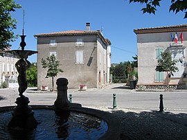 The centre of Saint-Amadou | |
 Coat of arms | |
show Location of Saint-Amadou | |
 Saint-Amadou | |
| Coordinates: 43°06′44″N 1°43′28″E / 43.1122°N 1.7244°ECoordinates: 43°06′44″N 1°43′28″E / 43.1122°N 1.7244°E | |
| Country | France |
| Region | Occitanie |
| Department | Ariège |
| Arrondissement | Pamiers |
| Canton | Pamiers-2 |
| Government | |
| • Mayor (2020–2026) | Serge Villeroux[1] |
| Area 1 | 4.64 km2 (1.79 sq mi) |
| Population (Jan. 2018)[2] | 242 |
| • Density | 52/km2 (140/sq mi) |
| Time zone | UTC+01:00 (CET) |
| • Summer (DST) | UTC+02:00 (CEST) |
| INSEE/Postal code | 09254 /09100 |
| Elevation | 253–334 m (830–1,096 ft) (avg. 283 m or 928 ft) |
| 1 French Land Register data, which excludes lakes, ponds, glaciers > 1 km2 (0.386 sq mi or 247 acres) and river estuaries. | |


Saint-Amadou is a commune in the Ariège department in southwestern France.
Population[]
Inhabitants are called Saint-Amadouens.
| Year | Pop. | ±% |
|---|---|---|
| 1962 | 198 | — |
| 1968 | 215 | +8.6% |
| 1975 | 166 | −22.8% |
| 1982 | 156 | −6.0% |
| 1990 | 189 | +21.2% |
| 1999 | 215 | +13.8% |
| 2008 | 227 | +5.6% |
See also[]
References[]
- ^ "Répertoire national des élus: les maires". data.gouv.fr, Plateforme ouverte des données publiques françaises (in French). 2 December 2020.
- ^ "Populations légales 2018". INSEE. 28 December 2020.
| Wikimedia Commons has media related to Saint-Amadou. |
This Ariège geographical article is a stub. You can help Wikipedia by . |
Categories:
- Communes of Ariège (department)
- Ariège (department) geography stubs