Varaville
show This article may be expanded with text translated from the corresponding article in French. (December 2008) Click [show] for important translation instructions. |
Varaville | |
|---|---|
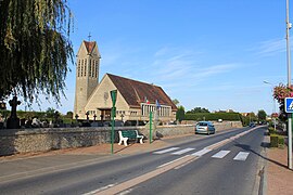 The church in Varaville | |
 Coat of arms | |
show Location of Varaville | |
 Varaville | |
| Coordinates: 49°15′15″N 0°09′25″W / 49.2542°N 0.1569°WCoordinates: 49°15′15″N 0°09′25″W / 49.2542°N 0.1569°W | |
| Country | France |
| Region | Normandy |
| Department | Calvados |
| Arrondissement | Lisieux |
| Canton | Cabourg |
| Government | |
| • Mayor (2008–2014) | Joseph Letorey |
| Area 1 | 16.49 km2 (6.37 sq mi) |
| Population (Jan. 2018)[1] | 976 |
| • Density | 59/km2 (150/sq mi) |
| Time zone | UTC+01:00 (CET) |
| • Summer (DST) | UTC+02:00 (CEST) |
| INSEE/Postal code | 14724 /14390 |
| Elevation | 2–20 m (6.6–65.6 ft) (avg. 20 m or 66 ft) |
| 1 French Land Register data, which excludes lakes, ponds, glaciers > 1 km2 (0.386 sq mi or 247 acres) and river estuaries. | |


Varaville is a commune in the Calvados department in the Normandy region in northwestern France.
It gives its name to the Battle of Varaville, which was fought in 1057.
Population[]
| Year | Pop. | ±% |
|---|---|---|
| 1793 | 186 | — |
| 1800 | 276 | +48.4% |
| 1806 | 319 | +15.6% |
| 1821 | 320 | +0.3% |
| 1831 | 254 | −20.6% |
| 1836 | 263 | +3.5% |
| 1841 | 292 | +11.0% |
| 1846 | 310 | +6.2% |
| 1851 | 292 | −5.8% |
| 1856 | 309 | +5.8% |
| 1861 | 297 | −3.9% |
| 1866 | 311 | +4.7% |
| 1872 | 261 | −16.1% |
| 1876 | 247 | −5.4% |
| 1881 | 250 | +1.2% |
| 1886 | 252 | +0.8% |
| 1891 | 289 | +14.7% |
| 1896 | 319 | +10.4% |
| 1901 | 320 | +0.3% |
| 1906 | 341 | +6.6% |
| 1911 | 366 | +7.3% |
| 1921 | 424 | +15.8% |
| 1926 | 488 | +15.1% |
| 1931 | 561 | +15.0% |
| 1936 | 524 | −6.6% |
| 1946 | 397 | −24.2% |
| 1954 | 570 | +43.6% |
| 1962 | 461 | −19.1% |
| 1968 | 511 | +10.8% |
| 1975 | 595 | +16.4% |
| 1982 | 729 | +22.5% |
| 1990 | 826 | +13.3% |
| 1999 | 815 | −1.3% |
| 2006 | 774 | −5.0% |
| 2008 | 795 | +2.7% |
See also[]
- Communes of the Calvados department
References[]
- ^ "Populations légales 2018". INSEE. 28 December 2020.
| Wikimedia Commons has media related to Varaville. |
| show Communes of the Calvados department |
|---|
This Calvados geographical article is a stub. You can help Wikipedia by . |
Categories:
- Communes of Calvados (department)
- Calvados (department) geography stubs