Vernajoul
show This article may be expanded with text translated from the corresponding article in French. (December 2008) Click [show] for important translation instructions. |
Vernajoul | |
|---|---|
Commune | |
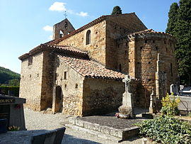 The church in Vernajoul | |
 Coat of arms | |
show Location of Vernajoul | |
 Vernajoul | |
| Coordinates: 42°59′15″N 1°36′27″E / 42.9875°N 1.6075°ECoordinates: 42°59′15″N 1°36′27″E / 42.9875°N 1.6075°E | |
| Country | France |
| Region | Occitanie |
| Department | Ariège |
| Arrondissement | Foix |
| Canton | Val d'Ariège |
| Intercommunality | CA Pays Foix-Varilhes |
| Government | |
| • Mayor (2020–2026) | Jean-Paul Ferré |
| Area 1 | 9.08 km2 (3.51 sq mi) |
| Population (Jan. 2018)[1] | 664 |
| • Density | 73/km2 (190/sq mi) |
| Time zone | UTC+01:00 (CET) |
| • Summer (DST) | UTC+02:00 (CEST) |
| INSEE/Postal code | 09329 /09000 |
| Elevation | 359–724 m (1,178–2,375 ft) (avg. 414 m or 1,358 ft) |
| 1 French Land Register data, which excludes lakes, ponds, glaciers > 1 km2 (0.386 sq mi or 247 acres) and river estuaries. | |


Vernajoul (French pronunciation: [vɛʁnaʒul]; Occitan: Vernajol) is a commune in the Ariège department in southwestern France.
Population[]
Inhabitants of Vernajoul are called Vernajoulois.
| Year | Pop. | ±% |
|---|---|---|
| 1962 | 392 | — |
| 1968 | 429 | +9.4% |
| 1975 | 516 | +20.3% |
| 1982 | 546 | +5.8% |
| 1990 | 541 | −0.9% |
| 1999 | 574 | +6.1% |
| 2008 | 688 | +19.9% |
See also[]
References[]
- ^ "Populations légales 2018". INSEE. 28 December 2020.
| Wikimedia Commons has media related to Vernajoul. |
| Authority control |
|---|
This Ariège geographical article is a stub. You can help Wikipedia by . |
Categories:
- Communes of Ariège (department)
- Ariège (department) geography stubs