Vierville-sur-Mer
Vierville-sur-Mer | |
|---|---|
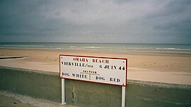 Dog White and Dog Red sectors on Omaha Beach | |
 Coat of arms | |
show Location of Vierville-sur-Mer | |
 Vierville-sur-Mer | |
| Coordinates: 49°22′30″N 0°54′14″W / 49.375°N 0.9039°WCoordinates: 49°22′30″N 0°54′14″W / 49.375°N 0.9039°W | |
| Country | France |
| Region | Normandy |
| Department | Calvados |
| Arrondissement | Bayeux |
| Canton | Trévières |
| Intercommunality | CC Isigny-Omaha Intercom |
| Government | |
| • Mayor (2020–2026) | Antoine de Bellaigue |
| Area 1 | 6.41 km2 (2.47 sq mi) |
| Population (Jan. 2018)[1] | 228 |
| • Density | 36/km2 (92/sq mi) |
| Time zone | UTC+01:00 (CET) |
| • Summer (DST) | UTC+02:00 (CEST) |
| INSEE/Postal code | 14745 /14710 |
| Elevation | 0–62 m (0–203 ft) (avg. 46 m or 151 ft) |
| 1 French Land Register data, which excludes lakes, ponds, glaciers > 1 km2 (0.386 sq mi or 247 acres) and river estuaries. | |


show This article may be expanded with text translated from the corresponding article in French. (December 2008) Click [show] for important translation instructions. |
Vierville-sur-Mer (French pronunciation: [vjɛʁvil syʁ mɛʁ] (![]() listen), literally Vierville on Sea) is a commune in the Calvados department in Normandy region in northwestern France.
listen), literally Vierville on Sea) is a commune in the Calvados department in Normandy region in northwestern France.
History[]
World War II[]

Black soldiers tracking a sniper Omaha Beachhead, near Vierville-sur-Mer, France. 10 June 1944

Honor guard with the flag and a bugler during a mass at the site of the first temporary cemetery in Vierville, June 10, 1944.
On 6 June 1944 (D-Day), the U.S. Army's 116th Infantry Regiment of the 29th Infantry Division, along with the 5th Ranger Battalion, and A, B, and C Companies of the 2nd Ranger Battalion landed on Dog Green, Dog White, Dog Red, and Easy Green sectors of Omaha Beach, below Vierville-sur-Mer, starting at 6.30 am.
Population[]
|
|
See also[]
- Communes of the Calvados department
References[]
- ^ "Populations légales 2018". INSEE. 28 December 2020.
External links[]
| Wikimedia Commons has media related to Vierville-sur-Mer. |
| show Communes of the Calvados department |
|---|
This Calvados geographical article is a stub. You can help Wikipedia by . |
Categories:
- Communes of Calvados (department)
- Calvados (department) geography stubs