Épreville-en-Lieuvin
Épreville-en-Lieuvin | |
|---|---|
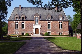 The manor house of the fief La Fortière | |
show Location of Épreville-en-Lieuvin | |
 Épreville-en-Lieuvin | |
| Coordinates: 49°12′11″N 0°32′14″E / 49.2031°N 0.5372°ECoordinates: 49°12′11″N 0°32′14″E / 49.2031°N 0.5372°E | |
| Country | France |
| Region | Normandy |
| Department | Eure |
| Arrondissement | Bernay |
| Canton | Beuzeville |
| Government | |
| • Mayor (2020–2026) | Jean-Nicolas Joubert[1] |
| Area 1 | 6.72 km2 (2.59 sq mi) |
| Population (Jan. 2018)[2] | 197 |
| • Density | 29/km2 (76/sq mi) |
| Time zone | UTC+01:00 (CET) |
| • Summer (DST) | UTC+02:00 (CEST) |
| INSEE/Postal code | 27222 /27560 |
| Elevation | 150–173 m (492–568 ft) (avg. 172 m or 564 ft) |
| 1 French Land Register data, which excludes lakes, ponds, glaciers > 1 km2 (0.386 sq mi or 247 acres) and river estuaries. | |


Épreville-en-Lieuvin (French pronunciation: [epʁəvil ɑ̃ ljøvɛ̃], literally Épreville in Lieuvin) is a commune in the Eure department in the Normandy region in northern France.
Population[]
| Year | Pop. | ±% |
|---|---|---|
| 1962 | 194 | — |
| 1968 | 201 | +3.6% |
| 1975 | 180 | −10.4% |
| 1982 | 192 | +6.7% |
| 1990 | 145 | −24.5% |
| 1999 | 169 | +16.6% |
| 2008 | 178 | +5.3% |
See also[]
- Communes of the Eure department
References[]
- ^ "Répertoire national des élus: les maires". data.gouv.fr, Plateforme ouverte des données publiques françaises (in French). 2 December 2020.
- ^ "Populations légales 2018". INSEE. 28 December 2020.
| Wikimedia Commons has media related to Épreville-en-Lieuvin. |
| show Communes of the Eure department |
|---|
This Eure geographical article is a stub. You can help Wikipedia by . |
Categories:
- Communes of Eure
- Eure geography stubs