Daubeuf-près-Vatteville
Daubeuf-près-Vatteville | |
|---|---|
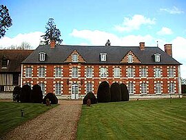 Chateau of Daubeuf-de-Nanteuil | |
 Coat of arms | |
show Location of Daubeuf-près-Vatteville | |
 Daubeuf-près-Vatteville | |
| Coordinates: 49°16′08″N 1°18′13″E / 49.2689°N 1.3036°ECoordinates: 49°16′08″N 1°18′13″E / 49.2689°N 1.3036°E | |
| Country | France |
| Region | Normandy |
| Department | Eure |
| Arrondissement | Les Andelys |
| Canton | Les Andelys |
| Government | |
| • Mayor (2020–2026) | Serge Colombel[1] |
| Area 1 | 11.35 km2 (4.38 sq mi) |
| Population (Jan. 2018)[2] | 462 |
| • Density | 41/km2 (110/sq mi) |
| Time zone | UTC+01:00 (CET) |
| • Summer (DST) | UTC+02:00 (CEST) |
| INSEE/Postal code | 27202 /27430 |
| Elevation | 23–141 m (75–463 ft) (avg. 144 m or 472 ft) |
| 1 French Land Register data, which excludes lakes, ponds, glaciers > 1 km2 (0.386 sq mi or 247 acres) and river estuaries. | |


Daubeuf-près-Vatteville (French pronunciation: [dobœf pʁɛ vatvil], literally Daubeuf near Vatteville) is a commune in the Eure department in northern France.
Population[]
| Year | Pop. | ±% |
|---|---|---|
| 1962 | 333 | — |
| 1968 | 337 | +1.2% |
| 1975 | 296 | −12.2% |
| 1982 | 307 | +3.7% |
| 1990 | 393 | +28.0% |
| 1999 | 425 | +8.1% |
| 2008 | 482 | +13.4% |
See also[]
- Communes of the Eure department
References[]
- ^ "Répertoire national des élus: les maires". data.gouv.fr, Plateforme ouverte des données publiques françaises (in French). 2 December 2020.
- ^ "Populations légales 2018". INSEE. 28 December 2020.
| Wikimedia Commons has media related to Daubeuf-près-Vatteville. |
| show Communes of the Eure department |
|---|
This Eure geographical article is a stub. You can help Wikipedia by . |
Categories:
- Communes of Eure
- Eure geography stubs