Clef-Vallée-d'Eure
Clef-Vallée-d'Eure | |
|---|---|
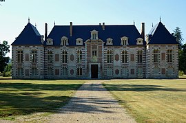 The chateau of La Croix-Saint-Leufroy | |
Location of Clef-Vallée-d'Eure  | |
 Clef-Vallée-d'Eure | |
| Coordinates: 49°06′32″N 1°14′35″E / 49.109°N 1.243°ECoordinates: 49°06′32″N 1°14′35″E / 49.109°N 1.243°E | |
| Country | France |
| Region | Normandy |
| Department | Eure |
| Arrondissement | Les Andelys |
| Canton | Gaillon |
| Intercommunality | CA Seine-Eure |
| Area 1 | 25.59 km2 (9.88 sq mi) |
| Population (Jan. 2018)[1] | 2,517 |
| • Density | 98/km2 (250/sq mi) |
| Time zone | UTC+01:00 (CET) |
| • Summer (DST) | UTC+02:00 (CEST) |
| INSEE/Postal code | 27191 /27490 |
| 1 French Land Register data, which excludes lakes, ponds, glaciers > 1 km2 (0.386 sq mi or 247 acres) and river estuaries. | |


Clef-Vallée-d'Eure is a commune in the department of Eure, northern France. The municipality was established on 1 January 2016 by merger of the former communes of La Croix-Saint-Leufroy, Écardenville-sur-Eure and Fontaine-Heudebourg.[2]
See also[]
- Communes of the Eure department
References[]
| Wikimedia Commons has media related to Clef Vallée d'Eure. |
- ^ "Populations légales 2018". The National Institute of Statistics and Economic Studies. 28 December 2020.
- ^ Arrêté préfectoral 4 December 2015 (in French)
Communes of the Eure department | |
|---|---|
|
This Eure geographical article is a stub. You can help Wikipedia by . |
Categories:
- Communes of Eure
- Populated places established in 2016
- 2016 establishments in France
- Eure geography stubs