La Ferrière-sur-Risle
From Wikipedia, the free encyclopedia
Commune in Normandy, France
La Ferrière-sur-Risle | |
|---|---|
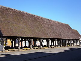 Medieval market hall | |
 La Ferrière-sur-Risle  La Ferrière-sur-Risle | |
Coordinates:  48°58′44″N 0°47′12″E / 48.9789°N 0.7867°E / 48.9789; 0.7867Coordinates: 48°58′44″N 0°47′12″E / 48.9789°N 0.7867°E / 48.9789; 0.7867 48°58′44″N 0°47′12″E / 48.9789°N 0.7867°E / 48.9789; 0.7867Coordinates: 48°58′44″N 0°47′12″E / 48.9789°N 0.7867°E / 48.9789; 0.7867 | |
| Country | France |
| Region | Normandy |
| Department | Eure |
| Arrondissement | Évreux |
| Canton | Conches-en-Ouche |
| Government | |
| • Mayor (2020–2026) | Marc Garreaud |
| Area 1 | 0.2 km2 (0.08 sq mi) |
| Population (Jan. 2018)[1] | 221 |
| • Density | 1,100/km2 (2,900/sq mi) |
| Time zone | UTC+01:00 (CET) |
| • Summer (DST) | UTC+02:00 (CEST) |
| INSEE/Postal code | 27240 /27760 |
| Elevation | 124–155 m (407–509 ft) (avg. 162 m or 531 ft) |
| 1 French Land Register data, which excludes lakes, ponds, glaciers > 1 km2 (0.386 sq mi or 247 acres) and river estuaries. | |

La Ferrière-sur-Risle (French pronunciation: [la fɛʁjɛʁ syʁ ʁil], literally La Ferrière on Risle) is a commune in the Eure department in the Normandy region in northern France.
Population[]
| Year | Pop. | ±% |
|---|---|---|
| 360 | 1,968 | — |
| 385 | 1,975 | +0.4% |
| 336 | 1,982 | +0.4% |
| 309 | 1,990 | +0.4% |
| 241 | 1,999 | +0.5% |
| 247 | 2,008 | +0.5% |
| 279 | — |
See also[]
- Communes of the Eure department
References[]
- ^ "Populations légales 2018". INSEE. 28 December 2020.
| Wikimedia Commons has media related to La Ferrière-sur-Risle. |
show
Communes of the Eure department | |
|---|---|
|
| show Authority control | |
|---|---|
| General | |
| National libraries | |
This Eure geographical article is a stub. You can help Wikipedia by . |
- v
- t
Retrieved from ""
Categories:
- Communes of Eure
- Eure geography stubs
Hidden categories:
- Articles with short description
- Short description is different from Wikidata
- Infobox mapframe without OSM relation ID on Wikidata
- Coordinates on Wikidata
- Pages using infobox settlement with image map1 but not image map
- Commons category link from Wikidata
- Articles with GND identifiers
- Articles with VIAF identifiers
- Articles with BNF identifiers
- Articles with WorldCat-VIAF identifiers
- All stub articles
- Pages using the Kartographer extension