Le Lesme
Le Lesme | |
|---|---|
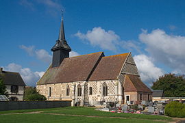 The church of Sainte-Marguerite in Sainte-Marguerite-de-l'Autel | |
Location of Le Lesme  | |
 Le Lesme | |
| Coordinates: 48°53′56″N 0°51′18″E / 48.899°N 0.855°ECoordinates: 48°53′56″N 0°51′18″E / 48.899°N 0.855°E | |
| Country | France |
| Region | Normandy |
| Department | Eure |
| Arrondissement | Bernay |
| Canton | Breteuil |
| Government | |
| • Mayor (2020–2026) | Jean-Claude Surmulet |
| Area 1 | 26.50 km2 (10.23 sq mi) |
| Population (Jan. 2018)[1] | 675 |
| • Density | 25/km2 (66/sq mi) |
| Time zone | UTC+01:00 (CET) |
| • Summer (DST) | UTC+02:00 (CEST) |
| INSEE/Postal code | 27565 /27160 |
| 1 French Land Register data, which excludes lakes, ponds, glaciers > 1 km2 (0.386 sq mi or 247 acres) and river estuaries. | |


Le Lesme (French pronunciation: [lə lɛm]) is a commune in the department of Eure, northern France. The municipality was established on 1 January 2016 by merger of the former communes of Sainte-Marguerite-de-l'Autel and Guernanville.[2]
See also[]
- Communes of the Eure department
References[]
| Wikimedia Commons has media related to Le Lesme. |
- ^ "Populations légales 2018". The National Institute of Statistics and Economic Studies. 28 December 2020.
- ^ Arrêté préfectoral 4 December 2015 (in French)
Communes of the Eure department | |
|---|---|
|
This Eure geographical article is a stub. You can help Wikipedia by . |
Categories:
- Communes of Eure
- Populated places established in 2016
- 2016 establishments in France
- Eure geography stubs