Authie, Calvados
Authie | |
|---|---|
 Authie Town Hall | |
show Location of Authie | |
 Authie | |
| Coordinates: 49°12′24″N 0°25′50″W / 49.2067°N 0.4306°WCoordinates: 49°12′24″N 0°25′50″W / 49.2067°N 0.4306°W | |
| Country | France |
| Region | Normandy |
| Department | Calvados |
| Arrondissement | Caen |
| Canton | Caen-2 |
| Intercommunality | CU Caen Mer |
| Government | |
| • Mayor (2020–2026) | Olivier Simar |
| Area 1 | 3.21 km2 (1.24 sq mi) |
| Population (Jan. 2018)[1] | 1,607 |
| • Density | 500/km2 (1,300/sq mi) |
| Time zone | UTC+01:00 (CET) |
| • Summer (DST) | UTC+02:00 (CEST) |
| INSEE/Postal code | 14030 /14280 |
| Elevation | 60–73 m (197–240 ft) (avg. 65 m or 213 ft) |
| 1 French Land Register data, which excludes lakes, ponds, glaciers > 1 km2 (0.386 sq mi or 247 acres) and river estuaries. | |


Authie (French: [oti] (![]() listen)) is a commune in the Calvados department in the Normandy region of north-western France.
listen)) is a commune in the Calvados department in the Normandy region of north-western France.
The inhabitants of the commune are known as Althavillais or Althavillaises.[2]
The commune has been awarded one flower by the National Council of Towns and Villages in Bloom in the Competition of cities and villages in Bloom.[3]
Geography[]
Authie is located some 6 km (4 mi) north-west of the centre of Caen. Access to the commune is by road D220 from Villons-les-Buissons in the north-east which passes through the centre of the commune and the village and continues to Carpiquet in the south. The D220C also goes south-east from the village to the urban area of Caen. There are also the hamlets of Hameau de Saint-Louet, Franqueville, Fermie du Calvaire, and Cussy in the commune. Apart from the large residential area the commune is entirely farmland.[4]
Toponymy[]
The name of the town is attested in the forms Alteium in 1227 and Auteya in 1264.[5]
Albert Dauzat matched Authie with Authie in Somme department (Altegiam 830) on the coastal river Authie (Alteia 723) and considers it primarily as a hydronym but does not provide any further explanation.[6]
According to René Lepelley this toponym is based on the pre-Celtic element alt in an unknown sense and is close to Authou in Pont-Authou.[7]
François de Beaurepaire sees a Gallic (Celtic) element in the alt in Authou.[8]
The Gallic term Attegia was recognized by Xavier Delamarre in Atheist-type names - e.g. Athis in the sense of "cabin or hut".[9]
This analyses to ad- (pre-verb) and tegia meaning "house" (cf. Old Irish teg, old Welsh tig, Welsh Ty, Old Breton tig, and Breton ti all meaning "house").[10]
It is likely that Authie contains the same element tegia preceded by another prefix. From a phonetic point of view there is a palatalization of the intervocalic consonant where [g] becomes [j] and then an Amuïssement or attenuation of [j]>[∅], a recurrent phenomenon in phonetics.
The same author explains that Arthies (Artegiae 680) may come from *Are-tegia which is a possible solution for Authie, knowing that [r] regularly becomes [l] before a consonant.
The name Altavilla is either a medieval romanization of a place named Hauteville as in Hauteville in Manche department and therefore does not relate to Authie. It may be a scribal error for *Alteia Villa or *Villa Alteia which mentions a villa, i.e. a rural area in medieval Latin, in a place called Alteia which is Authie.
History[]
In 1832 Authie (466 inhabitants in 1831) absorbed Saint-Louet-près-Authie (9 people)[11] in the west of its territory.
The commune was liberated on 8 June 1944 but was largely destroyed in the bombing.
Administration[]
This list is incomplete; you can help by . (April 2021) |
List of Successive Mayors[12]
| From | To | Name |
|---|---|---|
| 1983 | 2020 | Joël Pizy |
| 2020 | 2026 | Olivier Simar |
Twinning[]
Authie has twinning associations with:[13]
 North Baddesley (United Kingdom) since 1993.
Demography[]
In 2017 the commune had 1,595 inhabitants.
|
| ||||||||||||||||||||||||||||||||||||||||||||||||||||||||||||||||||||||||||||||||||||||||||||||||||||||||||||||||||
| Source: EHESS[14] and INSEE[15] | |||||||||||||||||||||||||||||||||||||||||||||||||||||||||||||||||||||||||||||||||||||||||||||||||||||||||||||||||||
Culture and heritage[]
Civil heritage[]
The commune has one site that is registered as an historical monument:
- An Ornamental Garden in the Château of Authie (18th century)
 [16]
[16] - The Monument to the Canadians dedicated to the victims of the taking of the village in 1944
Religious heritage[]

The commune has two religious buildings and structures that are registered as historical monuments:
The Church contains one item that is registered as an historical object:
- A Bronze Bell (1704)
 [19]
[19]
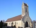
Saint Vigor church
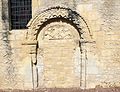
Saint-Vigor Portal
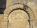
Detail on the Portal
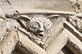
A detail on the church

The Vault in the church
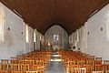
The Nave of the church
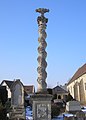
The Cemetery Cross


See also[]
- Communes of the Calvados department
External links[]
- Authie on Lion1906
- Authie on Géoportail, National Geographic Institute (IGN) website (in French)
- Authie on the 1750 Cassini Map
References[]
- ^ "Populations légales 2018". INSEE. 28 December 2020.
- ^ Inhabitants of Calvados (in French)
- ^ Authie in the Competition for Towns and Villages in Bloom Archived December 10, 2014, at the Wayback Machine (in French)
- ^ Jump up to: a b Google Maps
- ^ Albert Dauzat and Charles Rostaing, Etymological Dictionary of place names in France, Librairie Guénégaud Paris 6th edition, 1979, p. 39a. (in French)
- ^ Albert Dauzat and Charles Rostaing, op. cit.
- ^ René Lepelley, Etymological Dictionary of commune names in Normandy, Charles Corlet éditions PUC 1994, p. 54b - 55a. ISBN 978-2-905461-80-3 (in French)
- ^ The names of communes and old parishes in Eure, A. and J. Picard, François de Beaurepaire, preface by Marcel Baudot, 1981, Paris, 221 pages, ISBN 2-7084-0067-3, OCLC 9675154, p. 56 (in French)
- ^ Xavier Delamarre, Dictionary of the Gallic language, éditions Errance 2003, p. 59. (in French)
- ^ Xavier Delamarre, op. cit. (in French)
- ^ Des villages de Cassini aux communes d'aujourd'hui: Commune data sheet Saint-Louet-près-Authie, EHESS. (in French)
- ^ List of Mayors of France (in French)
- ^ National Commission for Decentralised cooperation (in French)
- ^ Des villages de Cassini aux communes d'aujourd'hui: Commune data sheet Authie, EHESS. (in French)
- ^ Population en historique depuis 1968, INSEE
- ^ Ministry of Culture, Mérimée IA80000395 Ornamental Garden in the Château of Authie (in French)
- ^ Ministry of Culture, Mérimée PA00111024 Church of Saint Vigor (in French)

- ^ Ministry of Culture, Mérimée PA00111023 Cemetery Cross (in French)
- ^ Ministry of Culture, Palissy PM80000272 Bronze bell (in French)
| Wikimedia Commons has media related to Authie (Calvados). |
| show Communes of the Calvados department |
|---|
- Communes of Calvados (department)