Badonviller
Badonviller | |
|---|---|
 The church in Badonviller | |
 Coat of arms | |
show Location of Badonviller | |
 Badonviller | |
| Coordinates: 48°29′52″N 6°53′40″E / 48.4978°N 6.89437°ECoordinates: 48°29′52″N 6°53′40″E / 48.4978°N 6.89437°E | |
| Country | France |
| Region | Grand Est |
| Department | Meurthe-et-Moselle |
| Arrondissement | Lunéville |
| Canton | Baccarat |
| Government | |
| • Mayor (2020–2026) | Bernard Muller[1] |
| Area 1 | 21.95 km2 (8.47 sq mi) |
| Population (Jan. 2018)[2] | 1,548 |
| • Density | 71/km2 (180/sq mi) |
| Time zone | UTC+01:00 (CET) |
| • Summer (DST) | UTC+02:00 (CEST) |
| INSEE/Postal code | 54040 /54540 |
| Elevation | 284–524 m (932–1,719 ft) (avg. 404 m or 1,325 ft) |
| 1 French Land Register data, which excludes lakes, ponds, glaciers > 1 km2 (0.386 sq mi or 247 acres) and river estuaries. | |


Badonviller (German: Badenweiler) is a commune in the Meurthe-et-Moselle department in northeastern France.
Population[]
|
|

Monument of the 358th Infantry Regiment

Military cemetery
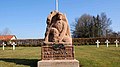
Statue carved February 15, 1916
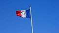
French flag in the military cemetery
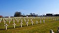
Crosses in the military cemetery
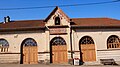
Covered market


Personalities[]
It is the birth town of the astronomer Charles Messier (1730–1817).
See also[]
- Communes of the Meurthe-et-Moselle department
- Badonviller March
- Badenweiler, Germany
- Antoine Sartorio
References[]
- ^ "Répertoire national des élus: les maires". data.gouv.fr, Plateforme ouverte des données publiques françaises (in French). 2 December 2020.
- ^ "Populations légales 2018". INSEE. 28 December 2020.
| Wikimedia Commons has media related to Badonviller. |
| show Authority control |
|---|
This Meurthe-et-Moselle geographical article is a stub. You can help Wikipedia by . |
Categories:
- Communes of Meurthe-et-Moselle
- Meurthe-et-Moselle geography stubs