Guenroc
Guenroc
Gwenroc'h | |
|---|---|
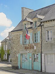 The town hall of Guenroc | |
 Coat of arms | |
show Location of Guenroc | |
 Guenroc | |
| Coordinates: 48°19′05″N 2°04′26″W / 48.3181°N 2.0739°WCoordinates: 48°19′05″N 2°04′26″W / 48.3181°N 2.0739°W | |
| Country | France |
| Region | Brittany |
| Department | Côtes-d'Armor |
| Arrondissement | Dinan |
| Canton | Broons |
| Intercommunality | Dinan Agglomération |
| Government | |
| • Mayor (2014–2020) | Simon Leterrier |
| Area 1 | 7.39 km2 (2.85 sq mi) |
| Population (Jan. 2018)[1] | 219 |
| • Density | 30/km2 (77/sq mi) |
| Time zone | UTC+01:00 (CET) |
| • Summer (DST) | UTC+02:00 (CEST) |
| INSEE/Postal code | 22069 /22350 |
| Elevation | 23–102 m (75–335 ft) |
| 1 French Land Register data, which excludes lakes, ponds, glaciers > 1 km2 (0.386 sq mi or 247 acres) and river estuaries. | |


Guenroc (Breton: Gwenroc'h, Gallo: Genroc) is a commune in the Côtes-d'Armor department of Brittany in northwestern France.
Population[]
| Year | Pop. | ±% |
|---|---|---|
| 1790 | 513 | — |
| 1796 | 507 | −1.2% |
| 1802 | 433 | −14.6% |
| 1838 | 526 | +21.5% |
| 1850 | 587 | +11.6% |
| 1870 | 560 | −4.6% |
| 1880 | 503 | −10.2% |
| 1913 | 412 | −18.1% |
| 1922 | 350 | −15.0% |
| 1938 | 339 | −3.1% |
| 1954 | 279 | −17.7% |
| 1962 | 268 | −3.9% |
| 1968 | 249 | −7.1% |
| 1975 | 193 | −22.5% |
| 1982 | 185 | −4.1% |
| 1990 | 176 | −4.9% |
| 1999 | 195 | +10.8% |
| 2008 | 97 | −50.3% |
Inhabitants of Guenroc are called guenrocois in French.
See also[]
References[]
- ^ "Populations légales 2018". INSEE. 28 December 2020.
External links[]
| Wikimedia Commons has media related to Guenroc. |
- Official website (in French)
- Base Mérimée: Search for heritage in the commune, Ministère français de la Culture. (in French)
This Côtes-d'Armor geographical article is a stub. You can help Wikipedia by . |
Categories:
- Communes of Côtes-d'Armor
- Côtes-d'Armor geography stubs