Troguéry
Troguéry
Trogeri | |
|---|---|
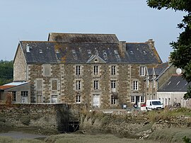 The mill in Troguéry | |
show Location of Troguéry | |
 Troguéry | |
| Coordinates: 48°45′17″N 3°13′28″W / 48.7547°N 3.2244°WCoordinates: 48°45′17″N 3°13′28″W / 48.7547°N 3.2244°W | |
| Country | France |
| Region | Brittany |
| Department | Côtes-d'Armor |
| Arrondissement | Lannion |
| Canton | Tréguier |
| Intercommunality | Lannion-Trégor Communauté |
| Government | |
| • Mayor (2020–2026) | Serge Henry[1] |
| Area 1 | 3.61 km2 (1.39 sq mi) |
| Population (Jan. 2018)[2] | 232 |
| • Density | 64/km2 (170/sq mi) |
| Time zone | UTC+01:00 (CET) |
| • Summer (DST) | UTC+02:00 (CEST) |
| INSEE/Postal code | 22383 /22450 |
| Elevation | 0–55 m (0–180 ft) |
| 1 French Land Register data, which excludes lakes, ponds, glaciers > 1 km2 (0.386 sq mi or 247 acres) and river estuaries. | |


Troguéry (Breton: Trogeri) is a commune in the Côtes-d'Armor department of Brittany in northwestern France.
Population[]
| Year | Pop. | ±% |
|---|---|---|
| 1962 | 274 | — |
| 1968 | 290 | +5.8% |
| 1975 | 238 | −17.9% |
| 1982 | 227 | −4.6% |
| 1990 | 224 | −1.3% |
| 1999 | 233 | +4.0% |
| 2008 | 284 | +21.9% |
People from Troguéry are known in French as troguérois.
See also[]
References[]
- ^ "Répertoire national des élus: les maires". data.gouv.fr, Plateforme ouverte des données publiques françaises (in French). 2 December 2020.
- ^ "Populations légales 2018". INSEE. 28 December 2020.
External links[]
| Wikimedia Commons has media related to Troguéry. |
- Base Mérimée: Search for heritage in the commune, Ministère français de la Culture. (in French)
This Côtes-d'Armor geographical article is a stub. You can help Wikipedia by . |
Categories:
- Communes of Côtes-d'Armor
- Côtes-d'Armor geography stubs